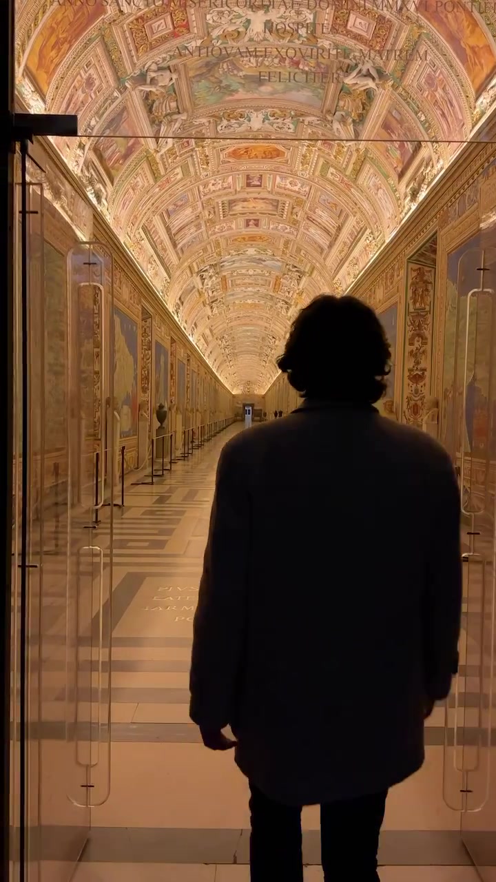
The ornate, fresco-covered hallways of the Vatican Museum give visitors a walk-through of history. The Vatican Museums offer more than a collection of art and historical artifacts — the Gallery of Maps specifically invites you into a timeless map-making era.
The Mapmaker's Expedition
The Gallery of Maps is a visual testament to the intricate craftsmanship of early cartographers. Established in the 16th century, the gallery spans over 120 meters and showcases 40 maps. Each map, meticulously depicted on frescoes, offers a detailed portrait of the Italian cities and regions as they were known during the reign of Pope Gregory XIII. The gallery’s unique characteristics set it apart from other museum experiences. The frescoes, painted by Ignazio Danti and his team, depict more than geographical information. They illustrate the economic, political, and social landscape of the regions, offering visitors a comprehensive historical perspective. Carlo Alberto Fusco, director of the Vatican Museums, notes that the maps aren't just historical artifacts but are timeless masterpieces of art.
A Closer Look at Cartographic Art
The Gallery of Maps exemplifies the convergence of science and art. This confluence is evident in the vibrant colors and minute details of the frescoes. Each map painstakingly represents detailed geographic information, along with historical sites, landmarks, and even mythological references.
The Art of Mapping
Each fresco is hand-crafted from egg-tempera paint, a fresco technique known for its durability and vibrant colors. The use of this technique reflects the expertise of the artists and their commitment to preserving the maps for future generations. The frescoes also incorporate diverse artistic styles, ranging from Renaissance to Baroque, which adds to their rich cultural tapestry. This artistic diversity highlights the blend of Italian heritage and cartographic precision that characterizes the gallery.
Thematic and Color Depth
The maps’ thematic focus extends beyond mere geography, incorporating artistic motifs that add depth. For example, mythological figures feature in the frescoes, which enhances the maps’ visual appeal. Each map is vibrantly colored, showcasing a variety of hues that reflect the cultural and artistic trends of the Renaissance period.
The Mapmaker as Historian
By depicting regional features, the Gallery of Maps serves as a historical document. The maps capture the political landscape of Italy during the 16th century, revealing the power dynamics and territorial divisions of the time. For instance, the boundaries and political entities shown on the maps reflect the geopolitical conditions of the Renaissance era. Visitors can see how Italy functioned as a collection of city-states, each with its own cultural identity and political administration.
Rediscovering History in Rome
The Gallery of Maps should be a must-stop for visitors on a Roman holiday. The Vatican Museums offer a rich exploration of the Catholic world's art and history. The Gallery of Maps is one of the museum’s featured exhibits, making it an essential part of the Vatican experience.
Your Guide to the Maps of Italy
Whether you're a historian, artist, or casual traveler, the Gallery of Maps offers an enriching experience. Here are some tips that can help you get the most out of your visit.
- Spend Time on Details: Each fresco is a masterpiece that includes minute details. Take time to observe the regions, landmarks, and artistic motifs.
- Consider a Guided Tour: Guided tours provide insights into the historical significance of the maps. These tours are available in multiple languages.
- Take a Moment to Reflect: The Gallery of Maps invites viewers to immerse themselves in history. Take a moment to reflect on the historical significance of each fresco once you’ve viewed the gallery.
A Map Through Time
Located in the heart of Vatican City, the Gallery of Maps is a treasure trove of art and history that beckons visitors to journey through the pages of Italy's past. These frescoes are testaments to the ingenuity of early mapmakers and artists. The Gallery stands as a captivating blend of art and geography, inviting visitors to explore the rich tapestry of Italy’s cultural and historical legacy.
Watch the Reel
Questions readers ask
What makes the Gallery of Maps unique compared to other map collections?
The Gallery of Maps stands out because it's not just a collection of maps but a series of frescoes that blend art and cartography. Each map is hand-painted with intricate details and vibrant colors, offering a comprehensive look at the political, economic, and social landscape of 16th-century Italy. Plus, the maps are housed in a 16th-century hallway, giving visitors a real sense of stepping back in time.
Can I visit the Gallery of Maps as part of a general Vatican Museum tour?
Yes, the Gallery of Maps is part of the Vatican Museums, and you can visit it as part of a general tour. It's one of the featured exhibits, so it's definitely worth including in your itinerary if you're exploring the Vatican Museums.
Who created the frescoes in the Gallery of Maps and what techniques did they use?
The frescoes were created by Ignazio Danti and his team. They used the egg-tempera paint technique, known for its durability and vibrant colors. This technique reflects the artists' expertise and their commitment to preserving these historical artifacts for future generations.
How do the maps in the Gallery of Maps go beyond just geography?
The maps in the Gallery of Maps offer more than just geographical information. They include historical sites, landmarks, and even mythological references. Each map is a rich tapestry that depicts the economic, political, and social landscape of the regions, providing a comprehensive historical perspective.
What historical period do the maps in the Gallery of Maps represent?
The maps in the Gallery of Maps represent the 16th century, specifically during the reign of Pope Gregory XIII. They provide a detailed portrait of Italian cities and regions as they were known during that time, offering insights into the political divisions and cultural identities of the Renaissance era.
What kind of artistic styles can be found in the Gallery of Maps?
The Gallery of Maps features a diverse range of artistic styles, from Renaissance to Baroque. This blend of styles adds to the rich cultural tapestry of the gallery, reflecting the Italian heritage and cartographic precision that characterizes the exhibit.
How do the maps in the Gallery of Maps reflect the political landscape of Italy?
The maps in the Gallery of Maps capture the political landscape of Italy during the 16th century, revealing the power dynamics and territorial divisions of the time. They show Italy as a collection of city-states, each with its own cultural identity and political administration, providing a detailed look at the geopolitical conditions of the Renaissance era.
Related deep dives
Similar reads based on topic and creator.



Recent articles
Fresh deep dives from the latest Reels we unpacked.

Comments
Be the first to comment.