Sinking Cities: A Growing Property Risk in the U.S.
The phenomenon of sinking cities, known scientifically as vertical land movement, poses a significant threat to urban infrastructure and safety. Out of America’s 28 largest cities, 25 are slowly sinking, creating a growing property risk. Vertical land movement contributes to infrastructure damage and increased flooding risks, necessitating careful urban planning and mitigation strategies.
Why This Matters
The sinking of cities is not a hypothetical future scenario; it is a present-day reality that affects millions of Americans. As urban areas continue to grow, the consequences of vertical land movement become more pronounced. Understanding which cities are most at risk and the specific rates at which they are sinking is crucial for informed planning and policy-making. The current sinking rates, measured in millimeters per year, highlight the urgency of addressing this issue to protect property and ensure the safety of residents.
The Data: Cities at Risk
Mapping the Problem
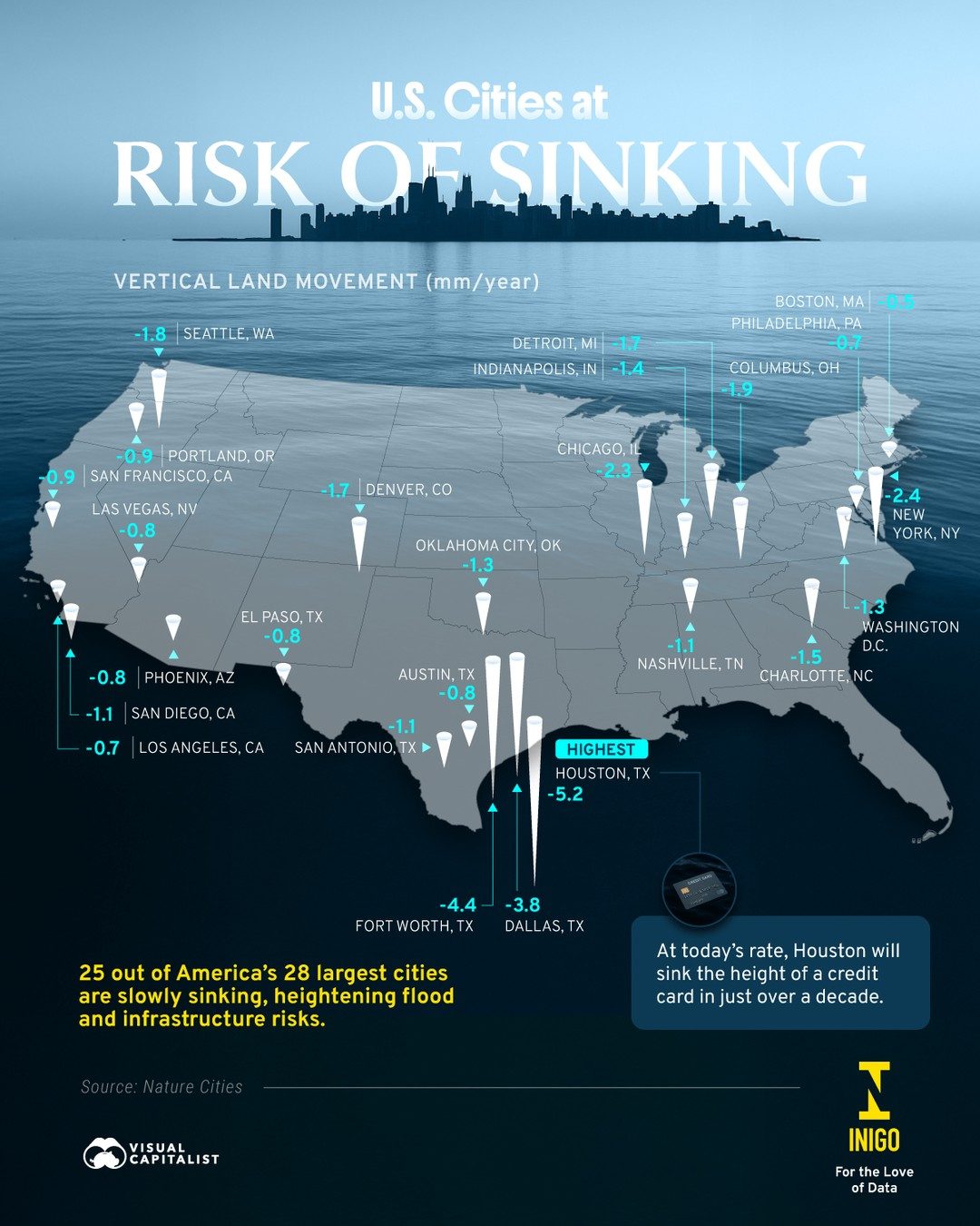
The data visualization maps major U.S. cities based on their vertical land movement rates, providing a clear picture of the areas most at risk. The rates range from slight to significant, with some cities experiencing alarming levels of sinking.
Key Cities and Their Sinking Rates
- Houston, TX: Houston tops the list with a sinking rate of -5.2 mm/year. At this rate, the city will sink the height of a credit card in just over a decade.
- Dallas, TX: Dallas follows closely with a sinking rate of -3.8 mm/year.
- Austin, TX: Austin is sinking at a rate of -1.5 mm/year.
- Los Angeles, CA: Los Angeles has a sinking rate of -1.1 mm/year.
- Seattle, WA: Seattle, with a sinking rate of -1.8 mm/year.
- Chicago, IL: Chicago’s sinking rate is -1.9 mm/year.
- San Francisco, CA: San Francisco is sinking at a rate of -1.8 mm/year.
- Portland, OR: Portland's sinking rate is -0.9 mm/year.
- Las Vegas, NV: Las Vegas is sinking at -0.8 mm/year.
- Denver, CO: Denver has a sinking rate of -1.7 mm/year.
- Columbus, OH: Columbus is sinking at a rate of -1.9 mm/year.
High-Risk Cities
Houston, TX, stands out as the most at-risk city, with a sinking rate of -5.2 mm/year. This high rate underscores the immediate need for intervention and mitigation strategies to protect the city’s infrastructure and residents. Dallas, TX, follows closely with a sinking rate of -3.8 mm/year, highlighting the broader risk in the region.
The Impact on Property and Infrastructure
The sinking of cities has far-reaching implications for property values and infrastructure. As land subsides, buildings, roads, and other structures become susceptible to damage, leading to increased maintenance costs and potential safety hazards. In coastal areas, sinking exacerbates the risk of flooding, compounding the challenges posed by climate change and rising sea levels.
Increased Flood Risk
For cities near coasts or bodies of water, sinking heightens the risk of flooding. As land levels drop, water levels relative to the land rise, making these areas more prone to inundation. This poses a significant threat to both residential and commercial properties, particularly in low-lying areas.
Infrastructure Damage
Sinking land can cause cracks and shifts in building foundations, roads, and bridges. This damage can lead to costly repairs and potential safety issues for residents and commuters. Urban planners and engineers must account for these risks when designing and maintaining infrastructure.
Practical Tips for Urban Planning and Mitigation
Addressing the issue of sinking cities requires a multi-faceted approach involving urban planners, engineers, and policymakers. Here are some practical steps to mitigate the risks associated with vertical land movement.
Monitoring and Data Collection
Regular monitoring of vertical land movement is essential for understanding the extent and rate of sinking in different areas. This data can inform urban planning decisions and help identify high-risk zones.
Strengthening Infrastructure
Building and maintaining infrastructure that can withstand the effects of sinking land is crucial. This includes designing structures with flexible foundations and using materials that can adapt to changes in land levels.
Flood Mitigation Strategies
In areas at high risk of flooding, implementing flood mitigation strategies such as elevated buildings, floodwalls, and improved drainage systems can help protect properties and infrastructure.
Urban Planning and Zoning
Urban planners can use data on vertical land movement to inform zoning decisions and land use policies. This may involve restricting development in high-risk areas or mandating specific construction standards for new buildings.
Public Awareness and Preparedness
Raising awareness among residents and businesses about the risks associated with sinking cities is vital. Public education campaigns can help people understand the importance of preparedness and the steps they can take to protect their properties.
Important Takeaways
The sinking of cities is a pressing issue that requires immediate attention and concerted efforts from various stakeholders. Understanding the rates at which different cities are sinking and the associated risks is the first step in developing effective mitigation strategies. By leveraging data and adopting proactive measures, urban planners and policymakers can work towards protecting properties and ensuring the safety of residents in at-risk areas.
Conclusion
The phenomenon of sinking cities highlights the need for vigilant monitoring, proactive planning, and robust mitigation strategies. As more data becomes available, it will be crucial to integrate this information into urban planning practices to safeguard against the risks posed by vertical land movement. By taking decisive action, we can mitigate the impacts of sinking cities and ensure the resilience of our urban environments.
Watch the Reel
Questions readers ask
Which U.S. cities are most at risk from vertical land movement?
Nearly two-thirds of the 28 largest cities in the U.S. are experiencing vertical land movement. Notable cities include Houston, San Francisco, and many others along the coasts and in the central United States.
What causes land to sink in urban areas?
Land subsidence in urban areas is primarily due to human activities like groundwater extraction and the compaction of soils beneath structures. Natural phenomena, such as tectonic activity, can also contribute to vertical land movement.
How does vertical land movement impact property owners?
Vertical land movement can lead to severe property damage, including cracks in buildings, damage to roads and bridges, and increased flood risks. These factors can significantly decrease property values and lead to costly repairs.
What is the sinking rate in cities like Houston and San Francisco?
Houston is sinking at an average rate of about 1.6 inches (40.64 mm) per year, while some areas of San Francisco are experiencing subsidence at rates up to 10 mm per year. These rates can vary within the cities, depending on the specific location and underlying geology.
How can urban planners mitigate the risks associated with sinking cities?
Urban planners can address the risks of sinking cities through careful planning and mitigation strategies. This includes monitoring groundwater levels, implementing stricter building codes, and developing infrastructure that can withstand the effects of land subsidence and increased flooding.
What role does data visualization play in understanding land subsidence?
Data visualization helps to map out areas at risk of sinking and track changes over time. It enables policymakers and urban planners to identify hotspots and prioritize areas for intervention, making it a vital tool in managing the impacts of vertical land movement.
What steps can homeowners take to protect their property from land subsidence risks?
Homeowners can take proactive steps to protect their property by conducting regular inspections, monitoring groundwater levels, and ensuring proper drainage. Additionally, obtaining comprehensive insurance coverage that includes land subsidence can provide financial protection against potential damages.
Related deep dives
Similar reads based on topic and creator.


Recent articles
Fresh deep dives from the latest Reels we unpacked.




Comments
Be the first to comment.