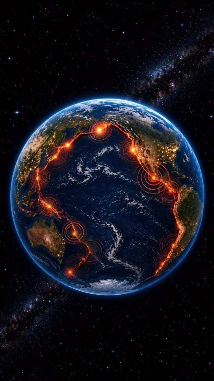
Earthquakes on the Pacific Ring of Fire
The Pacific Ring of Fire is a volatile patch of the world. It stretches from the southern tip of South America to the east coast of Asia. The epicentre of many seismic events, the Ring of Fire is a 40,000-km horseshoe-shaped basin in the Pacific Ocean and one of the most active earthquake zones in the world. Earthquake epicenters ripple outward from the Pacific Ring of Fire. The area is known for a high degree of volcanic activity as well as earthquake activity with, on average, 80 percent of the world's earthquakes occurring in this region. The mantle's convection currents, which transport heat from the core of the earth to the surface, are the primary drivers of the Earth's seismic activity. This activity is particularly noticeable in Indonesia, which is located in the Ring of Fire. This world-renowned danger zone contains more active volcanoes than any other region in the world. The country’s more than 130 active volcanoes attest to its tendency to shake. The recent preliminary report of a magnitude 6.1 earthquake in Bandasi, Indonesia, highlights the region’s persistence. The earthquake was roughly 100 kilometers deep.
Seismic Activity in Bandasi
Bandasi is one of the most dangerous places for earthquakes on the Ring of Fire due to its double subduction zone. A subduction zone is an area on Earth where one tectonic plate is moving underneath another. The tectonic plates of the Indo-Australian, Pacific, and Eurasian plates converge in the northern region of Indonesia and meet the Eurasian Plate in the Western Pacific region. Bandasi is on the boundary. Magnitude 6.1 earthquakes are quite shallow, occurring within the top 70 kilometers of the crust. Such moderate but shallow earthquakes are more common in subduction zones. Because the earthquakes occur closer to the surface, the shaking can be felt more severely and damage can be more widespread. Damage reports and any tsunami threat remain unconfirmed. Bandasi's notable seismic activity and geology are some of the reasons to monitor the Ring of Fire closely.
Visualizing Earthquakes
The seismic activity seen on the Earth from space is a representation of the energy released from the earthquakes. In the visualization, red lines and circles are overlaid on the globe. These overlaid markings highlight the areas of simultaneous seismic activity, showing the country's shifting plates. This visualization highlights the Earth’s spinning globe and the Ring of Fire, giving a sense of the planet’s seismic activity. The visualization serves a greater purpose. Through this visualization, scientists can analyze the frequency and intensity of these events, offering a better understanding of the geophysical processes at work. In essence, these representations are not merely aesthetic; they are crucial for scientific research and disaster preparedness.
Watch the Reel
Related deep dives
Similar reads based on topic and creator.
Recent articles
Fresh deep dives from the latest Reels we unpacked.

Comments
Be the first to comment.