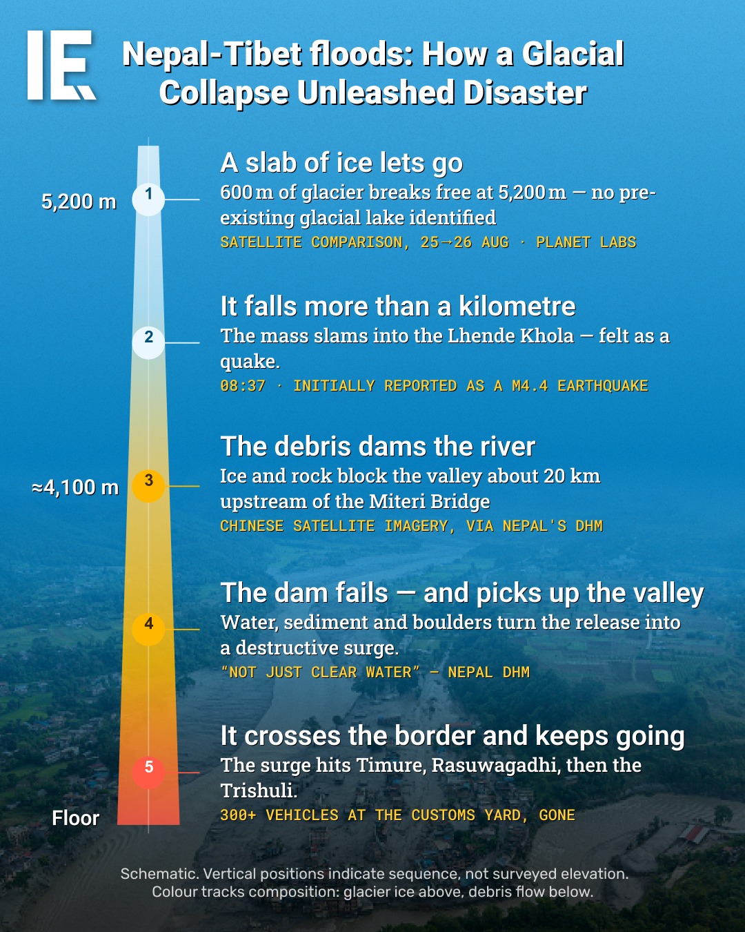
The Nepal-Tibet floods of late August 2023 began with a catastrophic event 5,200 meters above sea level. A 600m section of glacier broke free, sparking a catastrophic chain reaction. That event illustrates the sudden, devastating power of glacial collapse, a dramatic example of how climate change can reshape landscapes.
The mechanics of glacial collapse
The nature of glacial collapse is described through the lens of this massive event. Glacial collapse occurs when a section of a glacier suddenly breaks off and rapidly disintegrates, causing a flood of ice and debris, known as a glacier surge or glacial lake outburst flood. The sequence of events shown in the graphic helps illustrate how such an event unfolds. On August 25, 2023, a 600m section of a glacier at 5,200m in Nepal broke off and began its descent. The glacier surged down the mountain, carrying debris and ice, and eventually dammed a river. This dam formed around 20km upstream. Then, the debris from the glacier, 300+ vehicles, and other debris traveled more than a kilometer, reaching the Trishuli river past Timure and Rasuwagadhi. The surge impacted the region extensively, carrying debris and disrupting several settlements.
The global warming connection
Glacial surges aren't new, but researchers have observed explosive growth in these events in the last decade, making it a hot topic in the climate change discussion. This recent disaster in the border region of Nepal and Tibet fits into a broader global trend of increased glacial instability. that causes a chain reaction. These events can lead to flooding and debris flows, impacting areas downstream. Nepal provides a stark reminder of how climate change can force changes in glacial dynamics, causing devastating consequences to the local communities. Glacial surges are increasing in frequency and severity, affecting regions in Nepal, Pakistan, and other mountain regions. As temperatures continue to rise, the ice melts and thins, making glaciers more prone to collapse.
Refining disaster response
Tracking the Origin
Glaciers don't always have a history of glacier lake outburst floods. SATELLITE IMAGERY helped monitor the movements of the glacier, showing that the glacier broke off from a higher position. Downstream, the flood also impacted the road above Gamu, collapsing it. Given the rapid pace of the disaster, anyone who witnessed it would have been caught off guard. There was no way to know the disaster was coming. The glacier broke away with no warning signs such as earthquakes or earthquakes nearby.
The trail of debris and its usefulness
The debris caused significant damage, but it also provided vital clues. The trail of debris helped scientists track the movement of the glacier. The debris dammed the river and held it back for a while. But this dam failed, picking up even more debris and water as it surged downstream. Forensic analysis of debris and satellite imagery can help determine the exact path of the glacier.
Predictive modeling
Scientists use multiple data points to create predictive models. Scientific models for predicting glacial hazards rely on data such as elevation maps, seismic activity, and satellite imagery. Satellite imagery can compare previous images of glaciers to detect changes. These models can help predict where and when a glacier may collapse, allowing for better preparation and response. But predictive modelling also has its limitations. Models are only as accurate as the data used. It can be helpful to track events such as glacial surges.
Impact on local populations
These events can be devastating for local populations. 300+ vehicles were swept away. What can be done In practice, the practical angle usually lies in precautions to protect people, especially in different regions of the world. In Trans-Himalayan areas of Nepal and Tibet, these glaciated areas are prone to catastrophic glacial surges. Glaciers are melting, and the ice sheets around them are fractured, leading to unpredictable glacier surges. Communities at risk must take action to protect their land and reduce the possibility of devastating floods. Waiting for the next glacier surge to happen is not the answer. One of the most important ways to protect against glacier surges is to monitor glaciers. Researchers in the region do a lot of work studying glaciers and monitoring their movements. They can use satellite imagery and on-the-ground observations to keep an eye on glaciers and predict when they might collapse.
Charting a course forward
In the aftermath of the Nepal-Tibet floods, scientists and engineers see opportunities for better disaster planning. In Nepal and Tibet, local governments can develop flood control measures to protect against future disasters. These policies should ensure that communities are prepared and have the resources they need to recover. Each disaster event also provides new data for researchers to improve predictive models for better protection.
Watch the Reel
Questions readers ask
What exactly is a glacial collapse and how does it differ from a typical glacier melt?
A glacial collapse happens when a large portion of a glacier suddenly breaks off and rapidly disintegrates, causing a surge of ice and debris downstream. Unlike typical glacier melt, which is a gradual process, a glacial collapse is sudden and can lead to catastrophic flooding and debris flows, known as glacial lake outburst floods.
How did scientists determine the path of the glacier after the collapse?
Scientists used satellite imagery and forensic analysis of the debris to track the movement of the glacier. The trail of debris provided vital clues about the path the glacier took as it surged downstream, helping experts understand the sequence of events.
What role did climate change play in the Nepal-Tibet glacial flood?
Climate change contributed significantly to the Nepal-Tibet glacial flood by altering glacial dynamics. Rising temperatures cause glaciers to melt and thin, making them more prone to collapse. This event is part of a broader trend of increased glacial instability observed globally over the last decade.
How can predictive models help mitigate the risk of future glacial collapses?
Predictive models use data points such as elevation maps and seismic activity to forecast potential glacial hazards. These models can help identify areas at risk and provide early warnings, allowing communities to prepare and respond more effectively to such disasters.
What kind of warning signs, if any, preceded the Nepal-Tibet glacier collapse?
There were no immediate warning signs preceding the Nepal-Tibet glacier collapse. The glacier broke away suddenly without any preceding earthquakes or other noticeable events, making it difficult to predict or prevent the disaster.
What are the immediate impacts of a glacial collapse on downstream communities?
A glacial collapse can have devastating impacts on downstream communities. The surge of ice and debris can cause extensive damage, disrupt settlements, and lead to flooding. In the case of the Nepal-Tibet flood, the debris dammed a river and eventually surged downstream, affecting multiple areas.
Related deep dives
Similar reads based on topic and creator.


Recent articles
Fresh deep dives from the latest Reels we unpacked.



Comments
Be the first to comment.