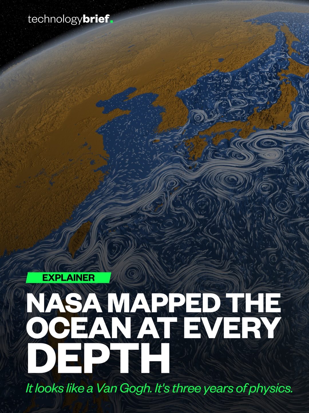
NASA has visualised the ocean in stunning detail using three years of physics data, providing an unprecedented view of underwater currents and depths. The resulting visualization resembles a Van Gogh painting, with intricate swirls and patterns that reveal the dynamic nature of the ocean.
Context / Why this matters
The ocean covers more than 70% of the Earth’s surface, yet much of its depth remains unexplored. NASA’s ocean depth mapping project sheds light on the complex movements and currents that shape our planet’s climate and ecosystems. By understanding these processes, scientists can better predict weather patterns, track climate change, and monitor the health of marine environments.
Main discussion
The ocean’s hidden dynamics
Underneath the ocean’s seemingly calm surface lies a world of constant motion. NASA’s visualization, created using the Estimation of Circulation and Climate Ocean (ECCO) model, tracks water parcels as they move around the planet. This model provides a clear view of currents that are usually invisible to the naked eye. The colors in the visualization represent different depths: white trails indicate water moving within the top 2,000 feet, while deeper currents are shown in varying shades of blue.
The Gulf Stream and its eddies
One of the most striking features of the visualization is the Gulf Stream, a powerful current that originates in the Gulf of Mexico and flows northwards along the eastern coast of the United States. The Gulf Stream is responsible for transporting vast amounts of warm water from the tropics to the North Atlantic, influencing the climate of Western Europe.
The visualization also highlights the formation of massive eddies or whirlpools within the Gulf Stream. These eddies can span hundreds of miles and maintain their shape for months. They are formed when the current sheds spinning rings of warm water, which then drift away and interact with the surrounding ocean. These eddies play a crucial role in distributing heat and nutrients across the ocean, shaping marine ecosystems and weather patterns.
How eddies form
The formation of eddies within the Gulf Stream is a complex process driven by the interplay of various factors, including wind, temperature, and the Earth’s rotation. As the Gulf Stream flows northwards, it encounters obstacles such as seamounts and undersea canyons, which can cause it to meander and form loops. These loops can eventually pinch off and form separate eddies that drift away from the main current.
The role of eddies in ocean dynamics
Eddies are not just passive features of the ocean; they actively influence its dynamics. They can trap and transport water, nutrients, and even marine life over long distances. Eddies also play a role in mixing the ocean’s layers, bringing nutrient-rich deep water to the surface and distributing heat and salt across different depths. This mixing is essential for supporting the diverse ecosystems found in the ocean.
The ocean’s role in climate regulation
The ocean is a key component of the Earth’s climate system, absorbing and redistributing vast amounts of heat and carbon dioxide. By mapping the ocean’s depths and currents, scientists can gain valuable insights into how it regulates the planet’s climate. For example, the ocean’s ability to absorb heat helps to moderate global temperatures and mitigates the effects of climate change. However, this also means that the ocean is warming and becoming more acidic, which has significant implications for marine life and ecosystems.
The Loop Current and the Gulf of Mexico
Another notable feature in the visualization is the Loop Current, a warm water current that flows northwards from the Caribbean into the Gulf of Mexico. The Loop Current is an extension of the Gulf Stream and plays a crucial role in the region’s climate and ecosystem.
The Loop Current is known for its unpredictable behavior, often forming large, warm-core eddies that can drift into the Gulf of Mexico and influence local weather patterns. These eddies can also disrupt oil and gas operations in the region, making it essential to monitor and predict their behavior.
Practical tips
While the visualization provides a mesmerizing view of the ocean’s depths, it also offers practical insights for various industries and scientific disciplines:
Marine navigation and safety
Understanding the dynamics of ocean currents and eddies is crucial for marine navigation and safety. Ships and submarines can use this information to plan their routes, avoid dangerous areas, and optimize fuel consumption.
Fisheries and marine conservation
Knowing the location and movement of eddies can help fisheries target schools of fish more effectively and sustainably. Additionally, understanding the role of eddies in mixing nutrients and supporting marine ecosystems can inform conservation efforts to protect vulnerable species and habitats.
Offshore industries
The oil and gas industry, as well as renewable energy developers, can benefit from a better understanding of ocean currents and eddies. This information can help them design more efficient and sustainable operations, as well as mitigate the environmental impact of their activities.
Important takeaways
NASA’s ocean depth mapping project offers a unique and captivating perspective on the dynamic nature of the ocean. Here are some key takeaways from the visualization:
- The ocean is a world of constant motion, with currents and eddies shaping its dynamics and influencing the planet’s climate.
- The Gulf Stream and its eddies play a crucial role in redistributing heat and nutrients across the ocean, supporting marine ecosystems and weather patterns.
- The Loop Current in the Gulf of Mexico is an essential feature that influences the region’s climate and ecosystem, as well as offshore industries.
- Understanding the ocean’s depths and currents is vital for marine navigation, fisheries, and offshore industries, as well as for monitoring and mitigating the effects of climate change.
Conclusion
NASA’s ocean depth mapping project provides a fascinating and informative glimpse into the hidden world beneath the ocean’s surface. By visualizing the complex dynamics of currents and eddies, researchers can gain valuable insights into the ocean’s role in shaping the planet’s climate and ecosystems. This information is not only crucial for scientific research but also has practical applications for industries and conservation efforts. The ocean may look relatively calm from above, but underneath, it’s always moving, and NASA’s visualization brings this dynamic world to life.
Watch the Reel
Questions readers ask
How does NASA's ocean depth mapping project work?
NASA's project utilizes three years of physics data to create detailed visualizations of the ocean floor and underwater currents. By analyzing data from satellites and other sources, scientists can map the complex patterns and dynamics of ocean currents, providing insights into their influence on climate and marine life.
What are ocean eddies and why are they important?
Ocean eddies are swirling masses of water that move in circular patterns. They play a significant role in distributing heat and nutrients across the ocean. By visualizing these eddies, NASA's research helps scientists understand how they contribute to climate patterns and support marine ecosystems.
How do underwater currents influence climate?
Underwater currents act as conveyor belts, transporting warm and cold water around the globe. This movement of water helps regulate global temperatures and influences weather patterns. By studying these currents, scientists can better predict climate changes and their impacts on various regions.
What makes NASA's ocean depth visualization unique?
NASA's visualization of the ocean depth is unique due to its intricate detail and aesthetic similarity to a Van Gogh painting. It showcases the dynamic and complex nature of underwater currents, offering a new perspective on the ocean's hidden dynamics and providing valuable information about the interplay between currents and our planet.
How can understanding deep ocean currents benefit marine ecosystems?
By gaining insights into deep ocean currents, scientists can better monitor the health of marine environments. These currents transport nutrients and oxygen to deep-sea habitats, supporting a wide range of marine life. Understanding these processes can help in the conservation and management of marine resources.
What role does satellite data play in NASA's ocean research?
Satellite data is crucial for NASA's ocean research as it provides a comprehensive view of the ocean's surface and subsurface dynamics. By collecting and analyzing this data, scientists can track the movement of currents, monitor changes in ocean temperatures, and study the impact of climate change on marine environments.
Related deep dives
Similar reads based on topic and creator.


Recent articles
Fresh deep dives from the latest Reels we unpacked.




Comments
Be the first to comment.