The Duality of Nature
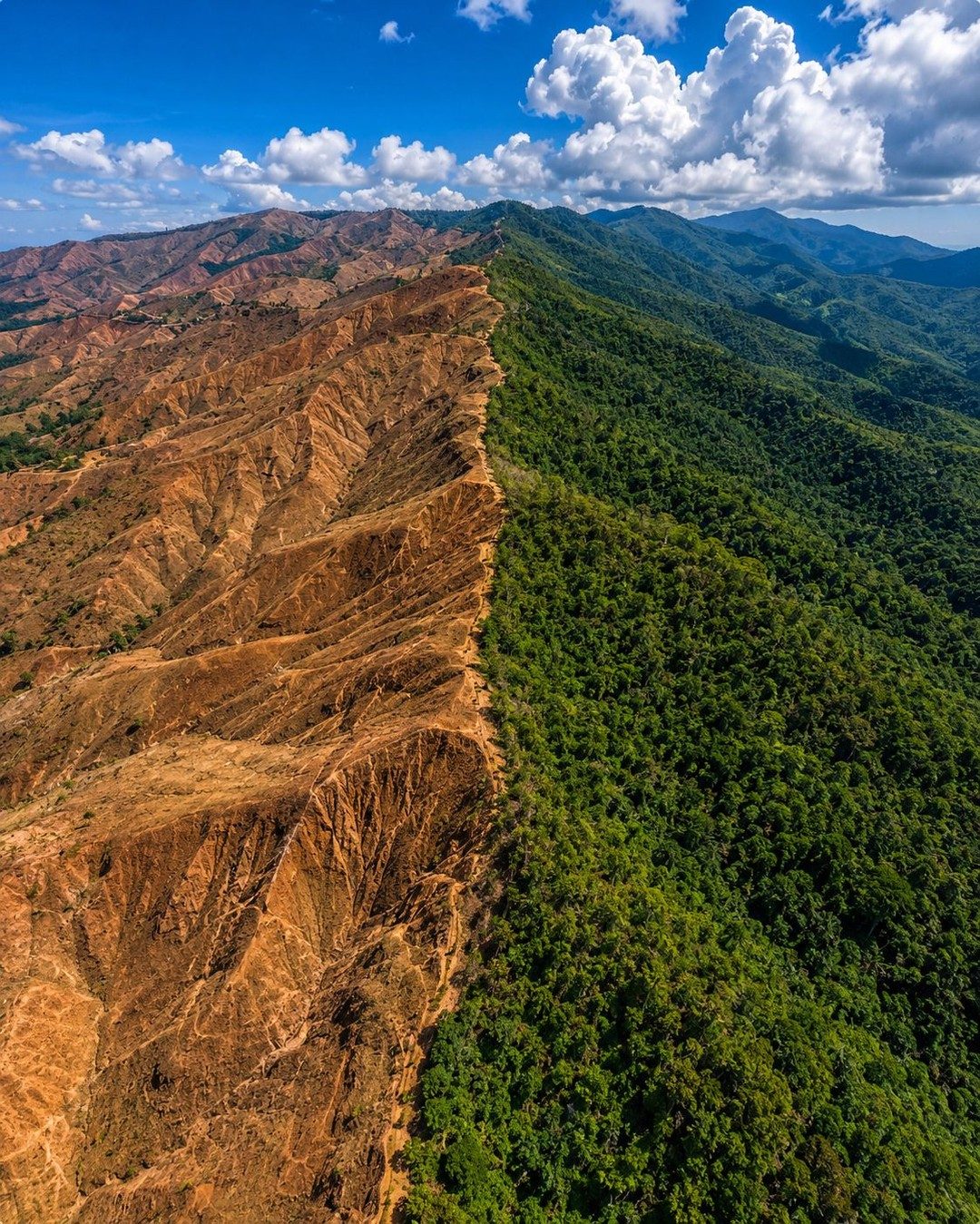
Nature's artistry is often celebrated for its beauty, but it’s equally stark in its depiction of contrasts. This particular aerial view of a mountain range showcases a dramatic landscape division occurring right in front of the viewer. The aerial perspective of this mountain range offers a panoramic view that might be missed from ground level. Such a top-down view is valuable not just for its aesthetics, but also for understanding the broader patterns and dynamics of a geographical area. The contrast between the vibrant, green vegetation and the barren, eroded terrain is stark. It serves as a visual reminder of nature's duality: the powerful forces that shape the terrain, as well as the delicate balance that sustains life. This contrast invites questions about the natural and human factors that contribute to the dramatic division of the landscape. Geological processes, deforestation, or other environmental factors can all shape the terrain in distinct ways. The contrast between the forested and eroded landscapes emphasizes the broader story of environmental change. These images serve as a visual narrative of environmental processes — revealing a landscape in transition. The one side of the mountain falls under the category of the lush green vegetation, highlighting the gift of mother earth, whereas the other side is barren and eroded. Human activities and climate change are often implicated in such transformations, making these landscapes a testament to the complex interplay of natural and man-made forces.
Aerial Perspectives and Environmental Insights
The aerial imagery of the mountain range presents a unique vantage point for environmental observation and analysis. This view covers expansive areas, allowing a wider lens on the environmental dynamics. The perspective is particularly useful for identifying broader patterns and gradients that might not be visible from the ground. These details are key for researchers and ecologists who analyze the health and changes in ecosystems. This perspective becomes an essential tool for monitoring environmental impacts, from assessing deforestation to understanding climate-driven changes. Environmental monitoring often relies on such aerial views to track ecological changes over time. Satellite and drone imagery allows scientists to monitor deforestation, track changes in vegetation, and gauge the impact of human activities over vast landscapes. The visual contrast in this mountain range can provide critical insights into how human activities and environmental factors are altering the terrain. Earth Observation data reveals how different parts of the landscape respond to natural and anthropogenic pressures. The environmental insights gained from this view can help inform conservation efforts, resource management, and climate change adaptation strategies.
The Impact on Local Ecosystems
The dramatic contrast between the forested and eroded landscapes highlights the potential impacts on local ecosystems. The forested area likely serves as a crucial habitat for various plant and animal species, providing shelter, food, and water. On the other hand, the barren, eroded terrain may struggle to support diverse ecosystems. Such stark differences in vegetation can significantly impact biodiversity, water cycles, and soil health. Ecosystem changes such as deforestation and erosion are often associated with broader environmental shifts. The eroded terrain showcases a fragile ecosystem, susceptible to further environmental stressors. The loss of vegetation cover can lead to soil erosion, reduced water retention, and decreased biodiversity. Meanwhile, the forested area acts as a carbon sink, absorbing carbon dioxide and mitigating climate change impacts. Protecting and restoring these ecosystems is essential for maintaining ecological balance and supporting biodiversity.
Understanding Environmental Processes
The aerial view of this mountain range showcases the natural and human factors shaping the landscape. The contrast between the lush green vegetation and the barren, eroded terrain reflects the complex interplay of geological processes and environmental changes. As the earth’s environmental changes intensify, so do the impacts on landscapes and ecosystems. It becomes crucial to understand these dynamics to preserve ecological balance. This aerial imagery offers a striking reminder of nature's resilience and the urgent need for sustainable practices.
Watch the Reel
Related deep dives
Similar reads based on topic and creator.

Recent articles
Fresh deep dives from the latest Reels we unpacked.

Comments
Be the first to comment.