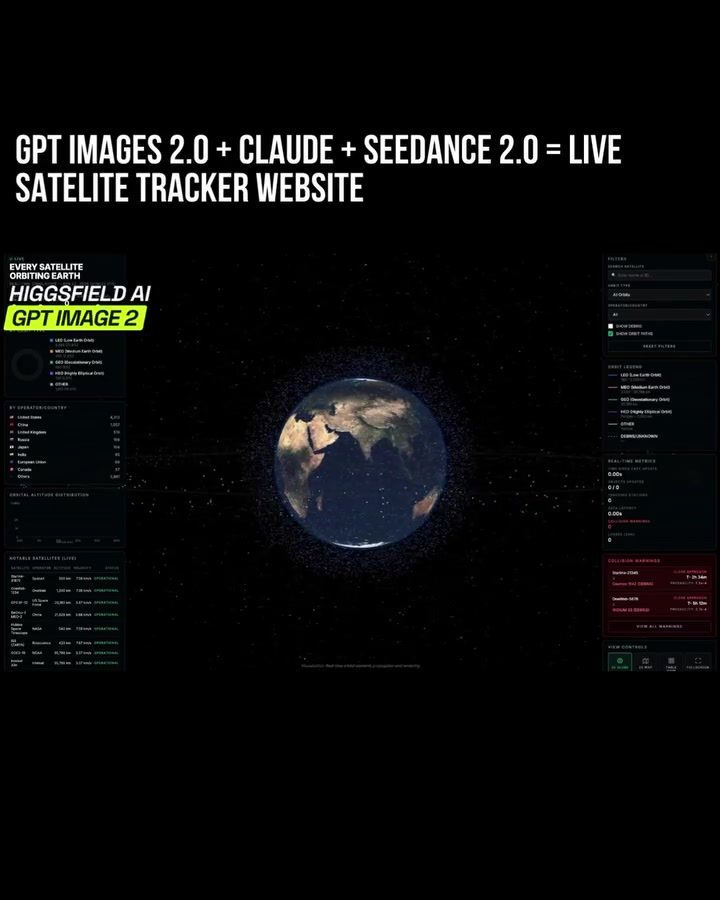
Satellite Tracker Website by HiggsField AI
Tracking satellites orbiting Earth is a complex task that requires advanced software and computational power. HiggsField AI has developed a sophisticated satellite tracker website that visualizes every satellite orbiting Earth, providing essential data and metrics. This tool is not just a marvel of technology but also a significant advancement in how we monitor and understand satellite movements.
Why this matters
The ability to track satellites in real-time is crucial for various applications, including scientific research, telecommunications, and national security. With the increasing number of satellites orbiting Earth, having a reliable and user-friendly tool to monitor their positions and metrics is more important than ever. The satellite tracker website by HiggsField AI offers a comprehensive solution that caters to both professionals and enthusiasts.
Main discussion
Visualizing Satellite Data
The satellite tracker website provides a visual representation of Earth with orbiting satellites. This visualization is not just aesthetically pleasing but also highly informative. Users can see the positions of satellites in real-time, which is essential for understanding their orbits and predicting future movements. The visual interface makes it easy to comprehend complex data, making the tool accessible to a broader audience.
Data and Metrics
The website offers a wealth of data and metrics related to satellite positions. These metrics include altitude, speed, and other critical parameters. This information is crucial for various applications, such as predicting satellite collisions and planning launches. The ability to access this data in real-time enhances the website's utility for professionals and researchers.
Filters for Refined Tracking
One of the standout features of the satellite tracker website is the availability of filters. These filters allow users to refine the display of satellites based on various parameters. For example, users can filter satellites by orbit type, such as Medium Earth Orbit (MEO) or Geostationary Orbit (GEO). This feature is particularly useful for professionals who need to focus on specific types of satellites for their work.
Practical tips
Navigating the Interface
To get the most out of the satellite tracker website, it's essential to familiarize yourself with the interface. The website is designed to be user-friendly, with intuitive controls and easy-to-understand visual elements. Take some time to explore the different features and filters to understand how they work.
Utilizing Filters
Filters are a powerful tool on the satellite tracker website. Experiment with different filters to refine your view of the satellites. For example, if you're interested in satellites in geostationary orbit, use the GEO filter to focus on those satellites. This can help you get more specific and relevant data for your needs.
Interpreting Data
The data and metrics provided by the website can be complex, but with a bit of practice, they become easier to interpret. Pay attention to the key parameters, such as altitude and speed, and how they change over time. This can give you a better understanding of satellite movements and their implications.
Important takeaways
- Comprehensive Tracking: The satellite tracker website by HiggsField AI provides a comprehensive view of every satellite orbiting Earth, making it an invaluable tool for professionals and enthusiasts alike.
- Real-Time Data: The ability to access real-time data and metrics is crucial for applications ranging from scientific research to national security.
- User-Friendly Interface: The website's intuitive design and user-friendly interface make it accessible to a broad audience, regardless of their technical background.
- Powerful Filters: The availability of filters allows users to refine their view of satellites, focusing on specific types and orbits as needed.
Conclusion
The satellite tracker website by HiggsField AI is a groundbreaking tool that provides real-time visualizations and data on every satellite orbiting Earth. With its user-friendly interface, comprehensive data, and powerful filters, it caters to a wide range of users, from professionals to enthusiasts. Whether you're conducting scientific research, planning a launch, or simply curious about satellite movements, this tool offers a wealth of information and insights. By leveraging the latest advancements in image processing and creative technology, HiggsField AI has created a tool that is both powerful and accessible, setting a new standard for satellite tracking.
Watch the Reel
Questions readers ask
How does the HiggsField AI Satellite Tracker provide real-time satellite tracking?
HiggsField AI's Satellite Tracker uses advanced software and computational power to deliver up-to-the-minute updates on the positions and movements of Earth's orbiting satellites. This real-time tracking is achieved through the integration of various data sources and sophisticated algorithms, ensuring users have accurate and current information.
What kind of data and metrics can I access with the HiggsField AI Satellite Tracker?
The HiggsField AI Satellite Tracker provides a comprehensive range of data and metrics, including the precise location, velocity, and orbital parameters of each satellite. Users can also access information on satellite health, communication status, and other relevant details, making it an invaluable resource for both professionals and enthusiasts.
Can the HiggsField AI Satellite Tracker be used for scientific research?
Yes, the HiggsField AI Satellite Tracker is an excellent tool for scientific research. It offers detailed, real-time data that can be used to study satellite dynamics, orbital mechanics, and environmental impacts. Researchers can utilize the tool to monitor specific satellites, analyze their trajectories, and gain insights into space phenomena.
How does the HiggsField AI Satellite Tracker benefit telecommunications?
The HiggsField AI Satellite Tracker is crucial for telecommunications by enabling real-time monitoring of communication satellites. This ensures optimal signal strength and reliable connectivity. Professionals in this field can use the tracker to manage satellite constellations, plan launch schedules, and mitigate potential disruptions in service.
Is the HiggsField AI Satellite Tracker useful for national security purposes?
Absolutely. The HiggsField AI Satellite Tracker plays a vital role in national security by providing real-time tracking of satellites, which is essential for monitoring space assets, detecting anomalies, and ensuring the integrity of satellite networks. This capability helps governments and defense agencies safeguard their space-based infrastructure and respond to potential threats.
What features make the HiggsField AI Satellite Tracker user-friendly?
The HiggsField AI Satellite Tracker is designed with a user-friendly interface that makes it accessible to both professionals and enthusiasts. It offers intuitive navigation, customizable views, and interactive visualizations of satellite orbits. The platform also provides search and filter options, allowing users to quickly find and analyze specific satellites or groups of satellites.
Can live satellite tracking images be accessed through the HiggsField AI Satellite Tracker?
Yes, the HiggsField AI Satellite Tracker offers live satellite tracking images, allowing users to visualize the real-time positions and movements of satellites in orbit. This feature is particularly useful for monitoring specific events, such as satellite launches or re-entries, and for gaining a better understanding of satellite dynamics and orbital mechanics.
Related deep dives
Similar reads based on topic and creator.




Recent articles
Fresh deep dives from the latest Reels we unpacked.




Comments
Be the first to comment.