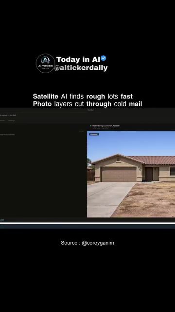
AI-Enhanced Real Estate Analysis: Revolutionizing Landscape Prospecting
AI is transforming the way real estate professionals analyze and prospect properties. By leveraging satellite imagery and advanced algorithms, AI tools can quickly identify potential sites, provide believable mockups, and streamline outreach efforts. This technology is particularly useful for landscaping and real estate development, offering a clear pathway from aerial views to inbox-ready proposals.
Why This Matters
The integration of AI in real estate analysis offers significant benefits for professionals in the field. Traditional methods of property analysis often involve time-consuming on-site visits, manual data collection, and guesswork. AI, on the other hand, can automate these processes, providing accurate and efficient analysis. This not only saves time but also increases the likelihood of identifying high-potential sites that might otherwise be overlooked.
Main Discussion
Satellite Imagery and AI Analysis
Satellite imagery plays a crucial role in AI-enhanced real estate analysis. High-resolution satellite images provide a detailed view of properties, allowing AI algorithms to identify key features such as terrain, vegetation, and infrastructure. This data is then analyzed to determine the suitability of a site for specific purposes, such as landscaping or development. For instance, AI can quickly scan for yards that look rough, indicating potential landscaping opportunities.
The Role of Photo Layers
Photo layers add another dimension to AI analysis. These layers can overlay additional information onto satellite images, such as property boundaries, zoning regulations, and environmental data. This integrated approach allows for a more comprehensive analysis, helping professionals make informed decisions. By cutting through the noise of cold mail and providing targeted insights, AI tools can help turn outreach efforts into booked jobs.
From Aerial View to Mockup to Inbox
One of the standout features of AI real estate analysis is its ability to streamline the process from aerial view to mockup and finally to the client's inbox. This seamless workflow is particularly beneficial for landscaping and real estate development. Here's how it works:
- Aerial View: Satellite imagery provides an aerial view of the property, allowing AI to identify potential sites.
- Mockup: The AI generates a believable after photo, showing what the property could look like after landscaping or development.
- Inbox: The final mockup is sent directly to the client's inbox, turning cold outreach into a warm, targeted proposal.
This loop not only saves time but also increases the likelihood of securing a job by providing a clear and compelling vision of the potential outcome.
Corey's Prospector and AI Ticker
AI Ticker, with its innovative tool "Corey’s prospector," exemplifies this technology. It scans satellite imagery for yards that look rough, renders a believable after photo, and helps turn cold outreach into booked jobs. This narrow wedge of landscaping showcases the power of AI in identifying opportunities and converting them into tangible results.
Practical Tips
Leveraging AI for Real Estate Analysis
If you're a real estate professional looking to integrate AI into your workflow, here are some practical tips:
- Choose the Right Tool: Select an AI tool that offers comprehensive analysis, including satellite imagery and photo layers. Tools like AI Ticker's "Corey’s prospector" provide a solid foundation for real estate analysis.
- Utilize Satellite Imagery: Ensure that your tool of choice has access to high-resolution satellite images. This will provide the detailed view necessary for accurate analysis.
- Integrate Photo Layers: Use photo layers to overlay additional information, such as zoning regulations and environmental data. This will give you a more comprehensive view of the property.
- Streamline Your Workflow: Look for tools that offer a seamless workflow from aerial view to mockup to inbox. This will save you time and increase the likelihood of securing jobs.
Important Takeaways
AI is revolutionizing the way real estate professionals analyze and prospect properties. By leveraging satellite imagery, photo layers, and advanced algorithms, AI tools can provide accurate and efficient analysis, saving time and increasing the likelihood of identifying high-potential sites. The integration of AI in real estate analysis offers significant benefits for professionals in the field, making it a valuable addition to any real estate toolkit.
Conclusion
AI-enhanced real estate analysis is transforming the industry by providing accurate, efficient, and comprehensive analysis. From identifying potential sites to generating believable mockups and streamlining outreach efforts, AI tools offer a clear pathway from aerial view to inbox-ready proposals. By leveraging AI, real estate professionals can stay ahead of the curve, securing jobs and driving growth in the industry.
Watch the Reel
Questions readers ask
How does AI use satellite imagery for real estate analysis?
AI analyzes satellite imagery by employing advanced algorithms to detect patterns and features indicative of viable real estate opportunities. This includes identifying undeveloped land, assessing property accessibility, and evaluating surrounding infrastructure, all of which can be crucial for property development.
What are the benefits of using AI for real estate outreach?
AI saves time with efficient property analysis, making it a powerful asset for real estate outreach. By quickly generating realistic mockups, it allows for more personalized and compelling proposals, thus improving the chances of successful negotiations and deals.
Can AI provide accurate property mockups?
Yes, AI can create highly accurate and realistic property mockups. Using satellite imagery and advanced algorithms, AI can generate detailed visualizations of potential development sites, helping stakeholders to understand the possibilities before making investment decisions.
How does AI streamline the real estate prospecting process?
AI streamlines real estate prospecting by automating the identification of promising properties. By analyzing satellite imagery, AI can quickly narrow down a large number of potential sites, enabling more efficient allocation of resources for on-site visits and detailed analysis.
What kinds of properties can AI identify through satellite analysis?
AI can identify a variety of properties through satellite analysis, including undeveloped land, vacant properties, and areas with potential for redevelopment. This broad range of identification capabilities makes AI a versatile tool for real estate professionals.
How does AI improve the accuracy of real estate analysis?
AI enhances the accuracy of real estate analysis by providing data-driven insights. By analyzing large datasets and identifying patterns that may not be apparent to the human eye, AI can offer a more comprehensive and objective assessment of potential properties.
What are the potential applications of AI in real estate development?
AI in real estate development can be used for site selection, environmental impact assessments, and infrastructure planning. By providing detailed property mockups and site analysis, AI can aid in creating more feasible and profitable development projects.
Related deep dives
Similar reads based on topic and creator.




Recent articles
Fresh deep dives from the latest Reels we unpacked.




Comments
Be the first to comment.