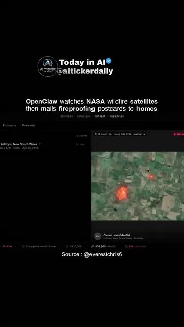
AI-Powered Real Estate Analysis: Monitoring Wildfires and Protecting Homes
AI-powered real estate analysis is revolutionizing how we approach property management, especially in disaster-prone areas. By leveraging advanced technologies, platforms like OpenClaw are at the forefront of integrating satellite data, AI, and real estate analytics to protect homes and communities from wildfires. This workflow not only identifies at-risk properties but also facilitates outreach to local contractors for necessary upgrades.
Context / Why This Matters
Wildfires pose a significant threat to properties, particularly in regions prone to such natural disasters. Traditional methods of monitoring and mitigating these risks often fall short due to their reactive nature and lack of real-time data. AI-powered solutions, such as those offered by OpenClaw, change the game by providing proactive, data-driven approaches to safeguarding homes.
Understanding the Workflow
Monitoring NASA Wildfire Satellite Alerts
OpenClaw leverages NASA's satellite data to monitor wildfire activity in real time. This sophisticated system tracks the movement and severity of wildfires, providing up-to-date information on potential threats. By integrating this data, OpenClaw can quickly identify areas at high risk of fire damage, allowing for immediate action.
Identifying Nearby At-Risk Homes
Once an area is identified as high risk, the system narrows down the properties within that vicinity. This targeted approach ensures that resources are allocated efficiently, focusing on the homes most in jeopardy. The ability to pinpoint at-risk properties is crucial for effective fireproofing measures.
Generating Fire-Hardening Upgrade Visuals
OpenClaw generates detailed visuals of the recommended fire-hardening upgrades for each property. These visuals not only help homeowners understand the necessary modifications but also serve as a blueprint for contractors. The specifics of these upgrades can vary but often include measures such as:
- Fire-resistant roofing materials
- Vegetation management
- Installation of fire retardant landscaping
- Reinforced windows and doors
Mailing Fireproofing Postcards
One of the standout features of the OpenClaw workflow is the automated mailing of fireproofing postcards to homeowners. These postcards contain essential information about the fire-risk status of their property and the recommended upgrades. This direct outreach ensures that homeowners are informed and can take proactive steps to protect their homes. For contractors, this also acts as a marketing tool, as they can be listed as providers for these upgrades.
Practical Tips for Implementing AI in Real Estate
Integrate Satellite Data
To reap the benefits of AI in real estate, integrating satellite data is essential. This provides a comprehensive view of the landscape, helping in precise risk assessment and planning.
Use Data-Driven Tools
Leverage AI tools that offer data-driven insights. These tools can automate many processes, from risk assessment to outreach, making the workflow more efficient and effective.
Collaborate with Local Contractors
Engaging local contractors in the process ensures that the recommended upgrades are carried out promptly and effectively. This collaboration also builds a network of trusted service providers.
Focus on Community Education
Reach out to homeowners with clear, actionable information. Educate them on the importance of fireproofing and how they can protect their properties. Regular updates and follow-ups can reinforce these messages.
Important Takeaways
AI-powered real estate analysis, as demonstrated by OpenClaw, is a powerful tool for monitoring and mitigating wildfire risks. By leveraging satellite data, AI, and real estate analytics, this approach offers a proactive solution to protecting homes and communities. The ability to automate outreach and provide detailed visuals of necessary upgrades makes it a comprehensive and effective system.
Conclusion
AI is changing the landscape of real estate management, especially in disaster-prone areas. By integrating advanced technologies, platforms like OpenClaw are setting new standards for proactive risk management. From monitoring wildfire alerts to automating outreach, these solutions offer a comprehensive approach to safeguarding properties. As we continue to face environmental challenges, embracing such technologies will be key to building resilient communities.
Watch the Reel
Related deep dives
Similar reads based on topic and creator.



Recent articles
Fresh deep dives from the latest Reels we unpacked.


Comments
Be the first to comment.