Eighth Continent Discovery
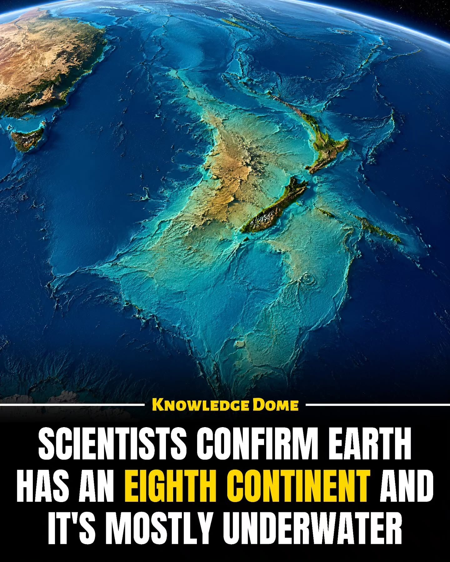
Deep beneath the waves lies a hidden continent, Zealandia, often referred to as Earth’s hidden eighth continent. Zealandia covers an astonishing area of nearly 5 million square kilometers, or about 2 million square miles, making it roughly the size of India. Yet, it remains largely unseen, as approximately 94% to 95% of it is submerged underwater. This leaves only a small portion of Zealandia visible above the water's surface, including the landmasses of New Zealand and New Caledonia.
Context / Why this matters
The existence of Zealandia is a fascinating geological mystery. Understanding its history and significance offers insights into the dynamic nature of our planet and the processes that shape its surface. Zealandia's unique characteristics challenge our traditional definitions of what constitutes a continent and provide a deeper understanding of Earth's geological past and present.
Zealandia: A Lost Continent
Origins and Formation
Long ago, Zealandia was part of the ancient supercontinent Gondwana. Around 83 million years ago, it began to separate from Antarctica and Australia. Over millions of years, Zealandia stretched, thinned, and gradually sank into the sea, becoming almost entirely submerged. This geological evolution is a testament to the powerful forces that continue to reshape our planet.
Geological Evidence
Scientists have studied Zealandia's rocks, underwater mountains, basins, and magnetic signals to confirm its status as a true continent. The geological evidence is compelling. The rocks on Zealandia exhibit unique characteristics that set them apart from the surrounding oceanic crust. The continent's topography, including its elevated plateaus and deep basins, further supports its identification as a distinct landmass.
Unique Characteristics
Unlike other continents, Zealandia's unique geological history has resulted in a landscape that is largely hidden from view. Its mostly submerged state makes it a challenging subject for study, yet it offers a wealth of information for geologists. The study of Zealandia provides insights into the processes of continental drift, plate tectonics, and the formation and erosion of landmasses.
Zealandia’s Role in Earth’s History
Gondwana Connection
The ancient supercontinent Gondwana was a massive landmass that included most of the landmasses in the Southern Hemisphere. Zealandia was once a part of this supercontinent, located between Antarctica and Australia. As Gondwana broke apart, Zealandia began its journey to become a separate continent.
Geological Transformations
The separation of Zealandia from Gondwana was a complex process that involved the stretching and thinning of the continental crust. Over millions of years, Zealandia's crust thinned to the point where it became less dense than the surrounding oceanic crust, causing it to sink lower into the sea. This geological transformation resulted in a continent that is mostly submerged, with only a small portion above water.
Practical tips for Exploring Zealandia
Research and Resources
For those interested in delving deeper into the study of Zealandia, there are several resources available. Scientific journals, books, and documentaries provide extensive information on the geological history and unique characteristics of this hidden continent. Engaging with these resources can offer a deeper understanding of Zealandia and its significance in Earth's geological history.
Online Maps and Visualizations
Utilizing online maps and 3D visualizations can provide a clearer picture of Zealandia's geographical extent. These tools allow for a virtual exploration of the continent, highlighting its underwater topography and key geographical features. Such resources are invaluable for visual learners and anyone interested in understanding the hidden world beneath the ocean's surface.
Important takeaways
- Zealandia, Earth’s hidden eighth continent, covers nearly 5 million square kilometers, with approximately 94% to 95% of it submerged underwater.
- Zealandia was once part of the ancient supercontinent Gondwana and began separating around 83 million years ago.
- Scientific studies of rocks, underwater mountains, basins, and magnetic signals confirm Zealandia’s status as a continent.
- Understanding Zealandia offers insights into continental drift, plate tectonics, and the dynamic nature of Earth’s surface.
- The unique geological history and mostly submerged state of Zealandia make it a fascinating subject for research and exploration.
Conclusion
Earth’s hidden eighth continent, Zealandia, is a geological treasure trove that offers valuable insights into the dynamic processes that shape our planet. Its mostly submerged state and unique geological characteristics make it a subject of great interest for scientists and the public alike. By studying Zealandia, we can better understand the complex history of our planet and the forces that continue to shape it.
Watch the Reel
Questions readers ask
What makes Zealandia considered the eighth continent if it is mostly underwater?
Zealandia is considered the eighth continent due to its large size and distinct geological features, similar to other continents. Although most of it is submerged, it has a well-defined crustal structure and a unique geological history that sets it apart from other underwater landmasses.
How does Zealandia challenge traditional definitions of continents?
Zealandia challenges traditional definitions of continents because it does not fit the typical model of a large, visible landmass. Its mostly submerged nature and unique geological history prompt scientists to reconsider what constitutes a continent, emphasizing the importance of geological criteria over visibility.
What is the relationship between Zealandia and New Zealand?
New Zealand is the largest landmass of Zealandia that is visible above water. It represents a small fraction of the total continent, which is mostly submerged beneath the ocean. Understanding New Zealand's geography and geology provides insights into Zealandia’s broader continental structure.
What are some key features that define Zealandia as a distinct continent?
Zealandia is defined by its large size, well-defined continental crust, and unique geological history. Despite being mostly underwater, it has clear boundaries and a distinct geological identity, which differentiates it from other oceanic regions.
How does studying Zealandia contribute to our understanding of Earth's continents?
Studying Zealandia helps scientists understand the dynamic processes that shape Earth's surface and the forces that drive continental formation and movement. By examining Zealandia, researchers gain a deeper understanding of the diverse geological histories of our planet's continents.
What are the visible landmasses of Zealandia, besides New Zealand?
Besides New Zealand, the most significant visible landmass of Zealandia is New Caledonia. These above-water portions of Zealandia offer scientists valuable opportunities to study the continent's geology and history, despite comprising only a small fraction of the continent's total area.
What are the implications of Zealandia being mostly underwater for our understanding of continental history?
The fact that Zealandia is mostly underwater adds a new dimension to our understanding that a continent can be hidden beneath the ocean. By studying Zealandia, scientists can better understand how oceanic and continental interactions have shaped Earth's surface over millions of years. This knowledge helps in mapping and studying other similar landmasses.
Related deep dives
Similar reads based on topic and creator.

Recent articles
Fresh deep dives from the latest Reels we unpacked.




Comments
Be the first to comment.