The Fault's Annual Worry
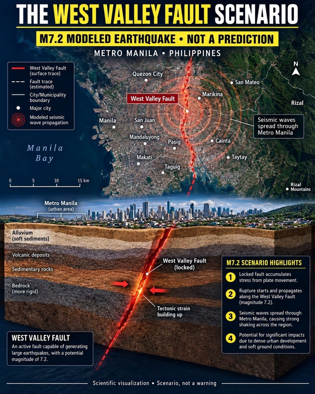
We might not see or feel it, but along the West Valley Fault in Metro Manila, stress is accumulating. Tectonic plates shift and scrape against each other, little by little. This stress has been building for countless years. When it suddenly releases, the ground is set to shake violently. This is one of the simple realities of seismology, even if no one knows exactly when it will happen. The West Valley Fault is a long and active fault line running through the densely populated Metro Manila. It stretches through the urban heart of the country, including cities like Quezon City, Manila, Makati, and Pasig. One of the worst-case scenarios it is capable of generating is a 7.2 magnitude earthquake. Although this magnitude is considered "major," it is a relatively small earthquake compared to the largest on record — the only point here is that it can happen with close to certainty. The Philippine Institute of Volcanology has demonstrated that when the West Valley Fault does finally rupture, the seismic waves are expected to spread radially outward from the fault, causing strong shaking across the metro Manila Region.
Urbanization vs. Earthquake
The Manila area sits upon a complex geological setting, with alluvial deposits, volcanic deposits, sedimentary rocks, and bedrock underneath the cities and municipalities. Imagine a thick layer of soft sediment covering a mass of solid granite. The impacts of the seismic waves are significantly amplified by the soft ground conditions. A readily observable example is Mexico city. The astounding variety of geological materials under the cities have their own unique seismic responses. In a densely populated urban area such as Metro Manila, an earthquake could have catastrophic impacts. As seen in past earthquakes in urban areas, the infrastructure damage can be extensive. Declaration of ruined buildings, displaced families, and fatalities can run into the thousands. Metro Manila is unfortunately likely to see the worst of it due to its vulnerable infrastructure, dense population, and extensive urban development. Many of the buildings may not be seismically retrofitted, leaving them susceptible to significant damage or even collapse. The specifics of seismic wave propagation in this scenario make the shaking it produces particularly dangerous. Starting roughly in Taytay, Rizal, the waves are modeled to spread outward to the cities of Manila, Quezon City, Makati, and even as far out as the municipalities of San Mateo and Taytay.
The Visualization & Its Purpose
The public needs to understand the what, how, and why of an earthquake. At the end of the what is an inevitable understanding of the how. Understanding how and when the ground will move is necessary for proper preparedness. The recommended steps involve securing heavy objects, identifying safe spaces, and planning evacuation routes. Allow for sufficient emergency supplies and communications for disaster response. The visualization teaches about a scenario. It visually models the propagation of seismic waves and highlights the areas most likely to be affected, and teaches viewers what to look for. The earthquake scenario visualizes the stress accumulation, rupture initiation, spreading of seismic waves, and resultant impacts. It shows exactly how a 7.2 magnitude earthquake could unfold, and how seismic waves are likely to propagate through the region. It highlights the critical role that urban development and soft ground conditions are expected to play in amplifying the earthquake's impacts.
Watch the Reel
Related deep dives
Similar reads based on topic and creator.

Recent articles
Fresh deep dives from the latest Reels we unpacked.

Comments
Be the first to comment.