Urban Heat Measurement: Understanding Temperature Variations
Urban areas often experience significant temperature variations, and understanding these differences is crucial for urban planning and public health. A thermal camera, a tool used to visualize temperature differences, can provide insights into how heat is distributed and how various elements within an urban landscape contribute to these differences.
Why This Matters
Urban heat is a critical factor in urban living, impacting everything from energy consumption to public health. Thermal cameras, which can detect and display the heat signatures of different elements within a scene, offer valuable information about how heat is distributed across an urban landscape. This is particularly important in densely populated areas where temperature variations can be extreme.
Heating in Urban Spaces
Surface Temperatures
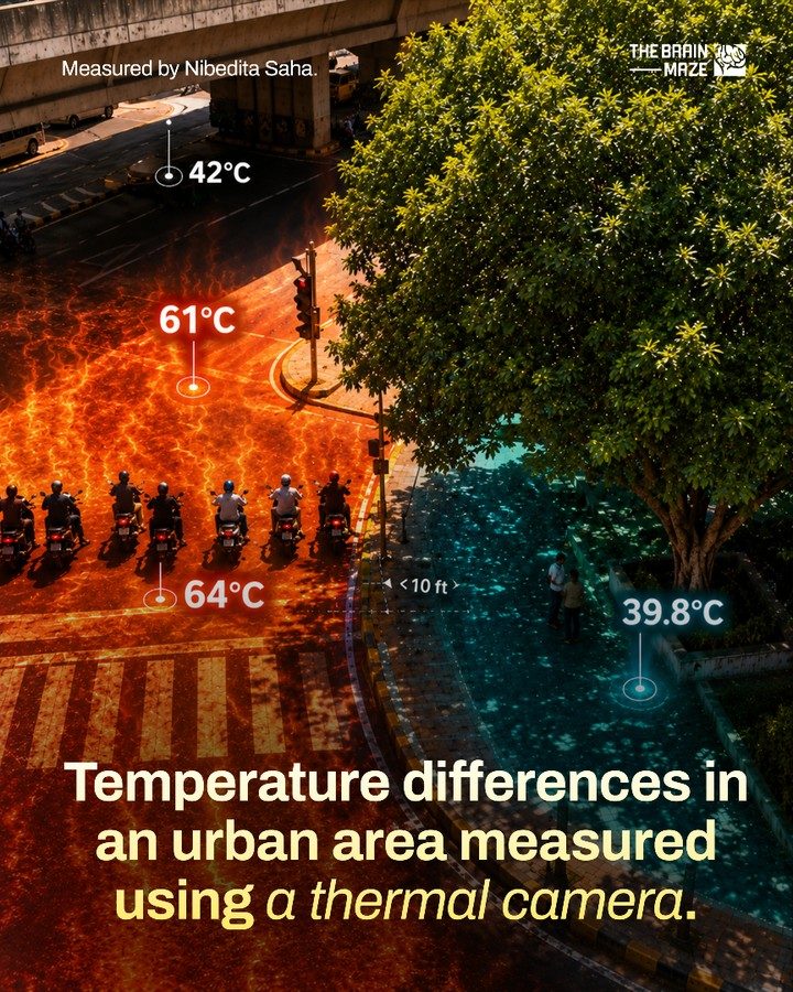
Surface temperatures in urban spaces can vary dramatically due to factors such as sunlight exposure, material composition, and shade. A study conducted by Nibedita Saha, a researcher at THE BRAIN MAZE using thermal cameras, revealed significant temperature differences in an urban area. For example, the pavement temperature was recorded at 61°C, while the air temperature around bikers waiting in direct sunlight reached 64°C. This highlights how exposed surfaces and direct sunlight can lead to extreme heat levels.
Shaded Areas
Shaded areas, such as those beneath flyovers or under trees, can provide significant relief from the heat. Under a flyover, the temperature was measured at 42°C, a notable difference from the 64°C in direct sunlight. This underscores the cooling effect of shade, which is essential in mitigating the urban heat island effect.
Importance of Green Cover
Green cover, such as trees and vegetation, plays a crucial role in urban cooling. Just 10 feet away from the 61°C pavement, the surface temperature under a tree cooled down to 39.8°C. This dramatic difference highlights the powerful cooling effect of urban greenery. Trees and other forms of green cover are not just aesthetically pleasing; they are essential tools in urban climate management.
Shade and Urban Planning
Urban Heat Island Effect
The urban heat island (UHI) effect is a phenomenon where urban areas are significantly warmer than their rural surroundings. This is primarily due to the abundance of heat-absorbing materials like concrete and asphalt, as well as the lack of vegetation. Shade and green cover are effective strategies to counteract the UHI effect by providing cooler areas and reducing the overall temperature in urban spaces.
Urban Design Strategies
Incorporating more shaded areas and green cover into urban design can significantly improve the quality of life for residents. Creating urban green spaces, planting trees along streets, and designing buildings with shaded areas can help mitigate the extreme heat levels experienced in urban environments.
Practical Tips
Using Thermal Cameras for Urban Heat Mapping
Thermal cameras are invaluable tools for urban planners and researchers. They can help identify hotspots and cooler areas, providing data that can guide urban planning decisions. For instance, thermal cameras can help in determining the best locations for planting trees, constructing shaded structures, and designing green spaces.
Creating Cool Urban Spaces
To create cooler urban spaces, consider the following tips:
- Increase Shade: Build more shaded structures like flyovers, pergolas, and awnings. This will provide relief from direct sunlight and reduce surface temperatures.
- Plant Trees: Trees not only provide shade but also cool the air through evapotranspiration. Planting trees along streets, in parks, and in residential areas can significantly reduce urban heat.
- Use Reflective Materials: Utilize reflective materials for paving and building surfaces. These materials can reduce heat absorption and keep urban spaces cooler.
- Green Roofs and Walls: Implementing green roofs and walls can help cool buildings and the surrounding environment. These features absorb heat and release cooler air, reducing the overall temperature.
Public Health Considerations
Understanding and mitigating urban heat is not just about comfort; it’s about public health. Extreme heat can lead to heatstroke, dehydration, and other health issues, particularly among vulnerable populations like the elderly and young children. Providing cooler spaces and educating the public about heat safety can save lives.
Important Takeaways
- Significant Temperature Variations: Urban areas can exhibit dramatic temperature differences due to factors like sunlight exposure, material composition, and shade.
- Powerful Cooling Effects of Green Cover: Trees and vegetation significantly reduce surface temperatures, providing essential cooling.
- Shaded Areas: Shaded structures can mitigate the urban heat island effect, creating cooler urban spaces.
- Thermal Cameras: These tools are invaluable for urban planners and researchers in identifying hotspots and cooler areas, guiding urban planning decisions.
- Urban Design Strategies: Incorporating shade and green cover into urban design can improve the quality of life for residents and reduce heat-related health risks.
Conclusion
Understanding and mitigating temperature variations in urban areas is crucial for creating livable and sustainable cities. Thermal cameras provide a powerful tool for visualizing these differences, highlighting the importance of shade and green cover in urban planning. By implementing practical strategies such as planting trees, constructing shaded structures, and using reflective materials, we can create cooler, more comfortable urban environments. This not only enhances the quality of life for residents but also addresses critical public health concerns related to urban heat.
Watch the Reel
Questions readers ask
What are the benefits of using a thermal camera in urban areas?
Thermal cameras help identify urban heat islands, map temperature variations, and understand how different surfaces like asphalt, concrete, and vegetation affect heat distribution. This information is crucial for city planners and public health officials to make informed decisions about urban design and policy.
How can thermal cameras assist in urban planning?
Thermal cameras can reveal temperature differences between shaded and exposed areas, helping urban planners design more efficient and comfortable spaces. By visualizing heat distribution, planners can strategically place green spaces, adjust building materials, and improve ventilation to mitigate heat-related issues.
What are urban heat islands and how can thermal cameras help?
Urban heat islands are areas in cities that are significantly warmer than their surrounding rural areas. Thermal cameras can help identify these areas by detecting and displaying heat signatures, allowing researchers and planners to assess the severity of the issue and implement targeted solutions.
Can thermal cameras be used for public health purposes in cities?
Yes, thermal cameras can help monitor and mitigate heat-related health risks by identifying hotspots in urban areas. This information can guide public health officials in providing cooling centers, issuing heat advisories, and implementing other protective measures during extreme heat events.
What is a thermal camera flyover and how is it useful in urban areas?
A thermal camera flyover involves mounting a thermal camera on a drone or aircraft to capture aerial thermal images of an urban area. This method provides a comprehensive view of heat distribution, helping researchers and planners identify large-scale patterns and trends in urban temperature variations.
How can thermal cameras assist researchers studying urban heat distribution?
Thermal cameras enable researchers to collect precise and detailed temperature measurements, allowing them to analyze how different urban elements like buildings, roads, and parks contribute to overall heat distribution. This data can inform models and simulations to predict future urban heat trends.
What are the best practices for using thermal cameras in urban areas?
For accurate measurements, use thermal cameras during clear weather and avoid direct sunlight. Conduct surveys at consistent times to minimize variability. Additionally, calibrate the camera regularly, and consider using a drone or elevated platform for a comprehensive view of the urban landscape.
Related deep dives
Similar reads based on topic and creator.


Recent articles
Fresh deep dives from the latest Reels we unpacked.



Comments
Be the first to comment.