Satellite Views and Cloud Dynamics
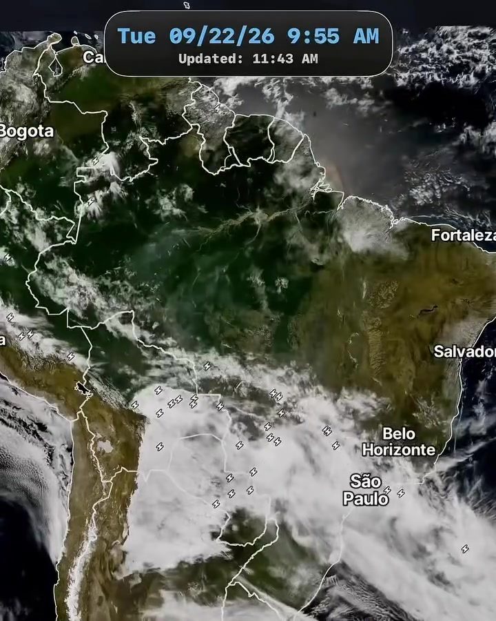
Satellite imagery offers an unprecedented vantage point for observing Earth's weather systems. The time-lapse video of South America reveals the intricate dance of cloud formations as they shift and transform over a short period. The view provides a rare glimpse of how air masses move and interact over the continent. Satellite imagery provides an unparalleled perspective, showing vast weather patterns that would otherwise go unnoticed from the ground. The diversity of cloud cover across South America is striking. The timeline of the video spans just a few hours. The satellite view shows that varying weather systems converge over distinct geographic regions, from the bustling urban centers of São Paulo and Belo Horizonte to the coastal stretches of Fortaleza and Salvador and the high-altitude capital, Bogotá. For viewers in specific cities, recognizing their locations amidst the swirling clouds prompts a silent question: "How does our city's weather fit into the larger puzzle of continental climate patterns?" These systems are not static, but dynamic, influenced by winds, temperature gradients, and other atmospheric forces, offering a fleeting snapshot of a constantly changing environment. The sheer scale of the satellite imagery underscores the complexity of weather systems. South America's varied geography, from the Amazon rainforest to the Andes mountains, plays a critical role in shaping these patterns. The way the weather patterns evolved over a short period showcases the continent's diversity. The clouds shift over urban centers, coastal regions, and mountain ranges, each geographic feature influencing the movement of air and moisture. This observation highlights the intricacy of climate dynamics through the path that the weather systems take.
Timelapse and Weather Progression
From Bogotá to Fortaleza, Salvador, Belo Horizonte, and São Paulo, the time-lapse captures the dynamic evolution of weather patterns. In the video, a single frame is updated every seven minutes. We see the clouds evolve over various regions, each region's weather system moving at its own pace. Each timestamp helps to track the movement of these systems over time, providing a clear picture of how quickly weather can change. The video spans an hour. The passage of time is marked by the progression of the timestamps, each one signaling a new view. The result is a visual record of how weather patterns move and transform, underscoring the dynamic nature of atmospheric conditions. These observations are particularly valuable for meteorologists, who rely on precise data to predict weather patterns. The video shows convective systems moving across the Brazilian interior and the Argentine plains. This tracking highlights the importance of satellite imagery in understanding how weather systems evolve over time. In a country so large, variation is inevitable, and the footage helps us appreciate the complexity of South America’s weather systems and how they rapidly shift.
The Role of Satellite Imagery in Weather Forecasting
The visual record of the moving clouds offer a larger picture that meteorologists use to track weather patterns. They monitor the movement of cloud formations, tracking how air masses shift and interact. This kind of observation helps scientists to predict weather patterns and develop accurate forecasts. The ability to capture this dynamic tension underscores an important aspect of how satellite imagery aids in weather forecasting. The data provided by satellite imagery helps meteorologists analyze and predict weather patterns more accurately, ensuring timely and reliable forecasts. Weather systems and their movements are not isolated events. They are influenced by various factors, including temperature differences, wind patterns, and geographical features. The satellite data helps meteorologists factor in these elements, improving their ability to predict long-term weather patterns and prepare for potential severe weather events.
Recognizing Urban Areas
The satellite view also prominently features several major South American cities, including Bogotá, Fortaleza, Salvador, and São Paulo. These urban areas give viewers familiar reference points as they view the weather systems. They are situated in a variety of geographic settings, from the dense urban landscape of São Paulo to the coastal regions of Fortaleza and Salvador. The video might not explicitly discuss urban areas, but it provides a stark picture of how weather systems intersect with human geography, revealing real-time weather patterns and their intersection with urban life. This intersection is vital for understanding how climate and weather influence daily life in South American cities.
Watch the Reel
Related deep dives
Similar reads based on topic and creator.


Recent articles
Fresh deep dives from the latest Reels we unpacked.

Comments
Be the first to comment.