Papua New Guinea’s Recent Seismic Activity
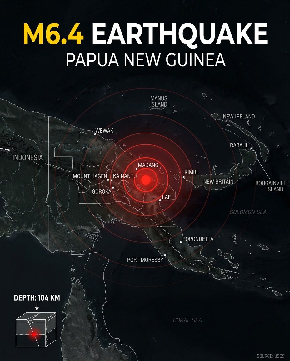
Earthquakes are a natural part of life for the inhabitants of Papua New Guinea. As a country located along the Pacific Ring of Fire, it experiences frequent seismic events. However, an earthquake of magnitude 6.4, which occurred with an epicenter 104 kilometers underground, is far more significant. The epicenter of this quake was detected by the United States Geological Survey (USGS) in the northern region of the country. It was deep enough to avoid critical damage, sparing the country's infrastructure. The proximity to populated areas, nevertheless, meant it had the potential to affect residents. The map provides a clear picture of the geography around the epicenter. Manus Island, Wewak, and New Ireland are just some of the locations close to the epicenter. This list includes large and small settlements, highlighting the breadth of the region impacted by the earthquake. The graphic also includes the Solomon Sea and the Coral Sea, providing context for the surrounding marine areas. Engineers and geologists would have monitored the earthquake's progression and spread beyond the epicenter. The depth of the epicenter is also critical. At 105 kilometers, it is relatively shallow for an earthquake, meaning the impact was immediate, but it wasn’t an immediate cause for alarm. The earthquake was a tangible reminder of the seismic activity that lies beneath the surface of our planet. These events underscore the need for preparedness and resilience in seismically active regions. The data collected by the USGS are invaluable for emergency preparedness.
The Critical Depth of a Seismic Event
The depth of an earthquake can determine how it affects an area. A deep earthquake, like the one 104 km below the surface, releases energy further from the surface. The seismic waves travel through the crust before reaching the surface. This means a deep earthquake like this one can spread out more over a larger area, reducing the intensity. The waves will encounter more resistance from the earth's crust, dispersing the energy. Depth can also affect the type of damage an earthquake causes. Shallow earthquakes are more likely to cause surface ruptures and significant damage to buildings and infrastructure. However, the deeper earthquake, like the one experienced in Papua New Guinea, is less likely to cause these kinds of damages. The bigger concern would be the secondary effects, such as tsunamis or landslides. The role of the USGS in seismological data collection and analysis cannot be overstated. The organization has a robust network of monitoring stations, including seismometers, GPS receivers, and other instruments. This allows them to provide timely and accurate information to the scientific community and the public. For earthquakes, USGS uses these networks to determine the magnitude, location, and depth of the quake. Moreover, it uses advanced data analysis techniques for precise forecasting of seismic activity.
New Ireland and its Neighbors
The earthquake occurred near New Ireland, one of the regions in central Papua New Guinea. Surrounded by large bodies of water, including the Coral Sea and Solomon Sea, New Ireland’s geographical positioning plays a crucial role in the impact of such seismic activities. There are important maritime considerations for this phenomenon. New Ireland lies between the North Bismarck Plate and the South Bismarck Plate, making it highly susceptible to tectonic activity. The epicenter, located in the northern section, was near Manus Island and Wewak. The Solomon Sea and Coral Sea are prominent bodies of water near the epicenter. These seas are known for their seismicity, as they lie within the seismically active Ring of Fire in the Pacific. This makes them susceptible to tsunamis, which are a significant hazard during earthquakes. The Solomon Sea, which sits between the Solomon Islands and Papua New Guinea, is particularly prone to such events. The presence of these seas complicates the potential impacts of earthquakes, both on the land and in the marine environment. The earthquake’s proximity to populated areas like Manus Island and Port Moresby is notable. These cities are densely populated and vibrant economic hubs. While the depth of the quake helped mitigate its impact, the potential for disruption or damage remains. This proximity underscores the need for community preparedness, including building codes and emergency response plans. Public safety measures become especially critical when dense populations are near the epicenter.
Watch the Reel
Related deep dives
Similar reads based on topic and creator.

Recent articles
Fresh deep dives from the latest Reels we unpacked.

Comments
Be the first to comment.