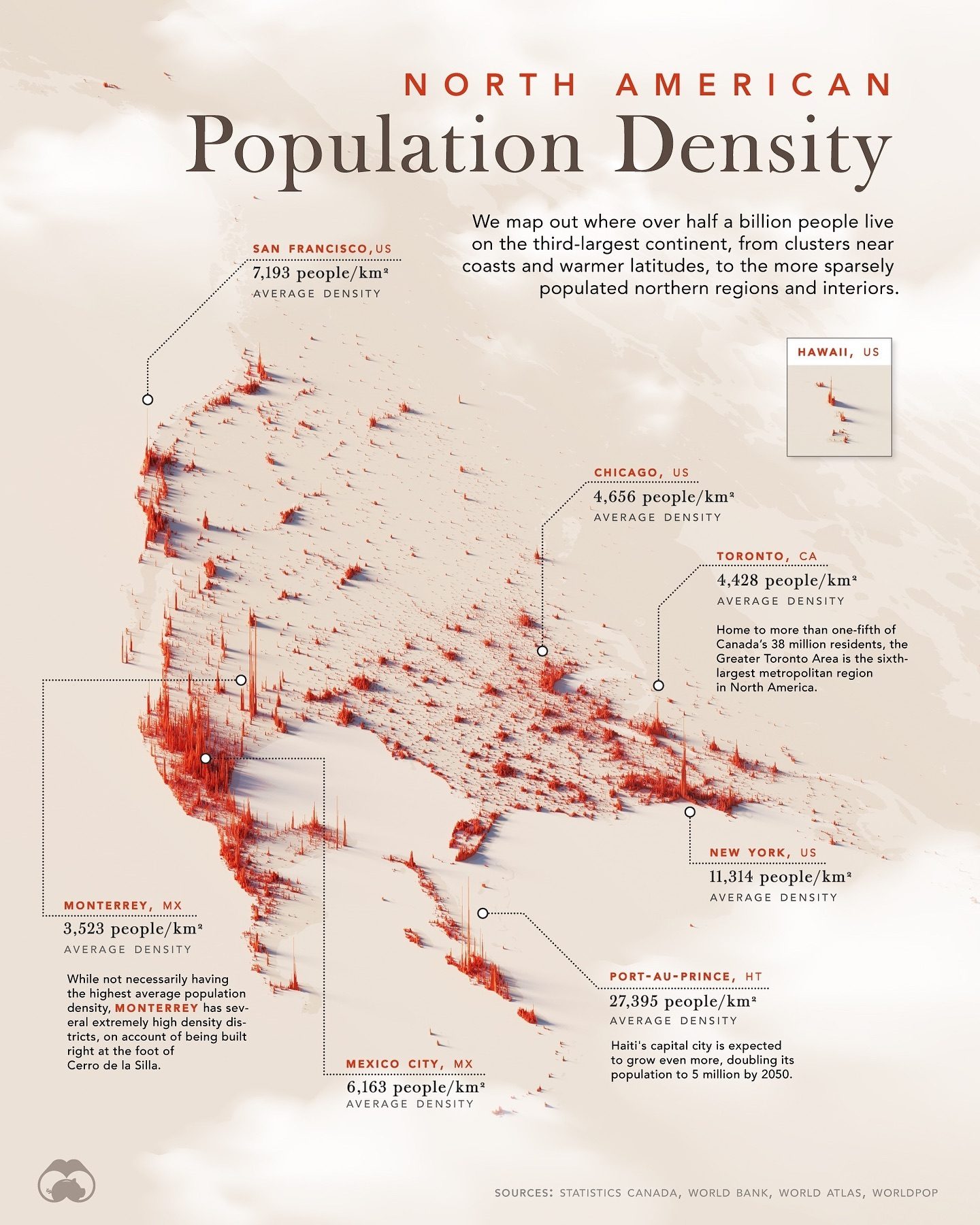
Population Density in North America
North America, spanning nearly 25 million square kilometers, is home to approximately half a billion people. This vast continent includes diverse landscapes, from sprawling rainforests to arid scrublands. Understanding the population distribution across North America, including Central America and the Caribbean, provides a unique perspective on how people have settled and thrived in this region. This map visualizes the population density across North American urban centers, highlighting densely populated areas and offering insights into how geography and urban planning influence where people live.
Why This Matters
Understanding population density is crucial for urban planning, resource allocation, and environmental management. High-density areas often face unique challenges, such as traffic congestion, housing shortages, and strain on public services. Conversely, low-density regions may struggle with infrastructure development and access to essential services. By examining the population density patterns in North America, we can better address these challenges and plan for sustainable growth.
Main Discussion
Key Cities and Their Population Densities
North America is home to some of the world's most densely populated cities. Here are a few notable examples:
San Francisco, US
San Francisco has an average population density of 3,293 people per square kilometer. The city's compact size and hilly terrain contribute to its high density, making it one of the most densely populated urban areas in the United States.
Chicago, US
Chicago, another major metropolitan hub, has an average population density of 4,656 people per square kilometer. The city's grid layout and extensive public transportation system help accommodate a large population within a relatively small area.
Toronto, CA
Toronto, Canada's largest city, has an average population density of 4,428 people per square kilometer. The Greater Toronto Area is the sixth-largest metropolitan region in North America, home to more than one-fifth of Canada’s 38 million residents. Toronto's population density reflects its role as a major economic and cultural center.
Monterrey, MX
Monterrey, Mexico, has an average population density of 11,314 people per square kilometer. However, it's important to note that Monterrey has several extremely high-density districts due to its unique geography. The city is built right at the foot of Cerro de la Silla, a prominent mountain, which limits its expandable area and contributes to its high population density.
New York, US
New York City, known for its skyscrapers and iconic landmarks, has an average population density of 11,314 people per square kilometer. The city's vertical growth and efficient public transportation system allow it to support a massive population within a compact area.
Port-au-Prince, HT
Port-au-Prince, the capital of Haiti, has an exceptionally high population density of 27,395 people per square kilometer. The city's rapid urbanization and limited land availability contribute to its extreme density, posing significant challenges for infrastructure and public services.
Mexico City, MX
Mexico City, one of the largest metropolitan areas in the world, has an average population density of 6,163 people per square kilometer. The city's extensive urban sprawl and high population density reflect its role as a major economic and political center in Mexico.
Factors Influencing Population Density
Several factors influence population density in North American cities. These include:
Geography and Terrain
The physical layout of a city can significantly impact its population density. Cities built on hilly or mountainous terrain, like Monterrey, often have higher population densities due to limited expandable land. Conversely, cities with flat terrain and ample land may have lower densities.
Urban Planning and Infrastructure
Effective urban planning and infrastructure development play a crucial role in accommodating high population densities. Cities with well-designed public transportation systems, efficient waste management, and adequate housing can support larger populations within smaller areas. For instance, Chicago and Toronto’s grid layouts and extensive public transportation networks help manage their high population densities.
Economic Opportunities
Cities that offer abundant job opportunities and economic growth tend to attract more people, leading to higher population densities. Major economic hubs like New York, Toronto, and Mexico City are prime examples of this trend.
Historical and Cultural Factors
Historical events and cultural factors can also influence population density. For example, the historical development of cities, migration patterns, and cultural preferences for urban living can all contribute to variations in population density.
Practical Tips for Understanding Population Density
To better understand population density in North America, consider the following tips:
- Look at historical data: Analyzing how population densities have changed over time can provide valuable insights into urban development and migration patterns.
- Study local geography: Understanding the physical layout and terrain of a city can help explain its population density. Cities built on hilly or mountainous terrain often have higher densities due to limited space.
- Examine urban planning strategies: Efficient urban planning and infrastructure development can greatly impact a city's ability to support a high population density. Look at factors like public transportation, waste management, and housing availability.
- Research economic opportunities: Cities with strong economic growth and job opportunities tend to attract more people, leading to higher population densities. Explore the economic landscape of different cities to understand their population density trends.
- Consider cultural factors: Historical events, migration patterns, and cultural preferences for urban living can all influence population density. Research the cultural and historical context of a city to gain a deeper understanding of its population dynamics.
Important Takeaways
- Population density is a critical factor in urban planning, resource allocation, and environmental management.
- North America's diverse geography and urban landscapes contribute to varied population densities across the continent.
- Key cities like Toronto, Monterrey, New York, and Port-au-Prince showcase how geography, urban planning, and economic opportunities influence population density.
- Understanding the factors that contribute to population density can help address challenges related to urban growth and sustainability.
Conclusion
Exploring the population density patterns across North America offers valuable insights into how people have settled and thrived in this vast and diverse continent. By examining the key cities and factors influencing population density, we can better understand the challenges and opportunities associated with urban growth. This knowledge is essential for effective urban planning, resource allocation, and environmental management, ensuring sustainable development for future generations.
Watch the Reel
Questions readers ask
What factors influence population density in North American urban centers?
Several factors influence population density in North American urban centers. Geography, such as the hilly terrain of San Francisco, can affect how compact a city becomes. Additionally, urban planning and design play a significant role, with some cities like Toronto and Chicago having more sprawling layouts. Historical development and economic factors also impact where and how densely people live.
How does the population density in cities like Toronto and Chicago differ?
Toronto and Chicago exhibit different population densities due to their unique urban planning and geography. Chicago, known for its sprawling layout, has a lower population density compared to Toronto, which has a more compact urban core. These differences highlight how urban design influences living conditions and resource distribution.
Why is understanding population density important for North American cities?
Understanding population density is vital for effective urban planning, resource allocation, and environmental management. It helps city planners and policymakers make informed decisions about infrastructure, public services, and sustainability efforts. By analyzing population density, cities can better address issues like traffic congestion, housing, and green spaces.
What insights can be gained from a population density map of North American cities?
A population density map of North American cities provides a visual representation of where people are concentrated and how urban centers compare to each other. It helps identify densely populated areas, understand the impact of geography on urban planning, and observe trends in population distribution across the continent, from the dense urban cores to the sprawling suburbs, and even into rural areas.
How does the population density of Monterrey compare to other major North American cities?
Monterrey, Mexico, has a unique population density influenced by its geography and urban planning. While it is one of the most populous cities, its density can vary significantly from other major North American cities. Monterrey's urban planning has led to a mix of dense urban areas and expansive suburbs, offering a different perspective on how population density can be managed in a growing metropolis.
What is the average population density in North American cities?
The average population density in North American cities can vary widely, given the diverse range of urban centers. While some cities like San Francisco and Toronto have higher densities due to compact urban cores, others like Chicago have lower densities due to their sprawling layouts. Metropolitan areas with unique geological factors, such as the hilly terrain of San Francisco, often exhibit higher densities compared to those with more sprawling designs.
How does urban planning impact the density in North American cities?
Urban planning significantly impacts the density in North American cities by determining how land is used and how infrastructure is developed. Cities with well-planned urban cores, like Toronto, tend to have higher densities, while those with more sprawling layouts, like Chicago, have lower densities. Urban planning also influences resource distribution and the quality of living conditions, making it a crucial factor in shaping a city's population density.
Related deep dives
Similar reads based on topic and creator.



Recent articles
Fresh deep dives from the latest Reels we unpacked.




Comments
Be the first to comment.