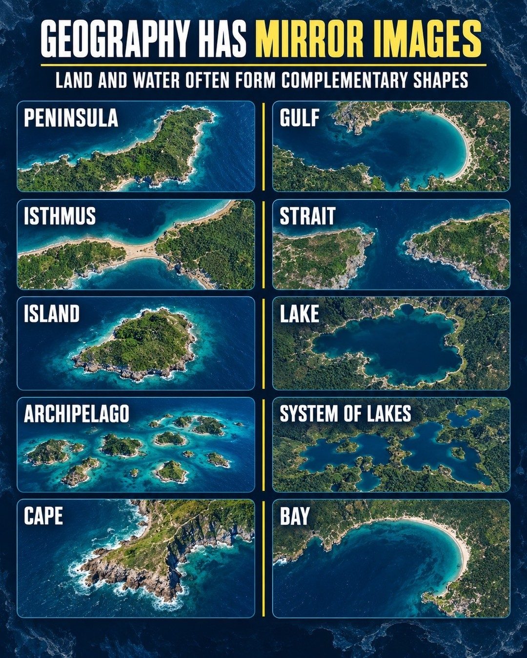
Geography as a fractal
In this context, fractal means self-similar patterns repeated at different scales. Geography isn't just about big landscapes. Look closer and see fractals in smaller areas. The shapes of land and water aren't random. Many interact in predictable ways, and almost act like complementary pieces on a massive puzzle. Take a peninsula and a gulf. The one is an example of a landmass jetting into the sea, while a gulf, by contrast, represents an indentation of sea into the coast. When lined up in your head, the two forms complete each other. Similarly, an isthmus, a narrow strip of land connecting two larger masses, and a strait, a narrow water passageway, are mirror images of each other. Mirroring can also be seen in smaller geographical features. Islands are surrounded by water, while lakes are surrounded by land. This binary relationship between land and water is the basis for the fractal nature of geography. Archipelagos, or groups of islands, and lake systems present this interaction in greater complexity. They mirror the bigger patterns of the continents and oceans. These emerging patterns echo the broader theme of geography: a story where land and water characters interact and influence each other.
Complementary shapes
You don't need super creativity to find these patterns. Consider the coastline, which turns out to be a fractal itself. It's filled with complementary shapes interacting at a local level. Capes jut into the sea, and bays cut inland into the land. The coastlines are a perfect example of how landscapes can exhibit this complementary duo. It's almost like the perfect statement "A cape doesn't exist without a bay. And, vice, versa. Not only do they help us understand coastlines, but also how the landscape weaves with the coastal water currents and temperament. The other geographial area where this is prominent is in the riverbank's edge. The riverbed curves and meanders into the land while the land through centuries of water erosion takes on the complementary shape. This is a perfect example of how geography exhibits itself in complementary shapes. Understanding these patterns can give someone an idea of how geography works. Look for these shapes in your manual or digital atlases. They are everywhere. A peninsula in Spain will have its own gulf's complementary shape. Identifying this give someone an idea how geography works. It's like an introduction to how geology interacts with geography to shape parts of the world.
The behavior of geographic forms
Landforms evolve over millions of years, sculpted by geological processes and the elements. Each geographical form therefore expresses thousands of years of water erosion. But sometimes, seeing how land and water interact and then form complementary shapes is very immediate. The landmass forms such as gulf and strait are perhaps the best examples. There’s an immediate interactivity of water and land forming different landforms. It’s easy to see how these landforms interact, but a harder task is trying to wrap your head around how long they've been interacting and shaping each other. As we alter our environment, understanding these relationships will become ever more important.
Watch the Reel
Related deep dives
Similar reads based on topic and creator.
Recent articles
Fresh deep dives from the latest Reels we unpacked.
Comments
Be the first to comment.