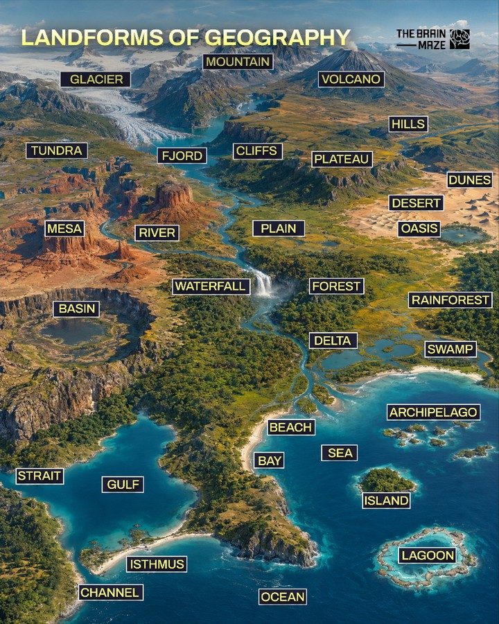
Landforms of Geography
Exploring the Earth's surface reveals a vast array of natural features, each with unique characteristics and formations. Landforms such as mountains, volcanoes, glaciers, and deserts not only shape the landscape but also influence climate, biodiversity, and human activities. Understanding these landforms provides insight into the dynamic processes that have sculpted our planet over millions of years.
Why This Matters
Studying landforms is essential for comprehending the Earth's geography, climate, and ecosystems. These features are not static; they evolve over time due to natural forces like erosion, tectonic activity, and climate change. Whether you're a student, a traveler, or simply curious about the world, knowing the different types of landforms and their significance can deepen your appreciation for the natural world.
Main Discussion
Mountains
Mountains are among the most iconic landforms, towering above the surrounding landscape. They are formed through tectonic activity, volcanic eruptions, and erosion. Mountains serve as natural barriers, influencing weather patterns and creating diverse ecosystems. Some of the world's most famous mountain ranges include the Himalayas, the Andes, and the Rocky Mountains.
Volcanoes
Volcanoes are openings in the Earth's crust where magma, ash, and gases escape. They can be active, dormant, or extinct. Volcanic activity can create new landforms and contribute to the formation of islands. Examples include the Hawaiian Islands, which were formed by volcanic activity, and Mount Fuji in Japan.
Glaciers
Glaciers are large, slow-moving masses of ice formed from compacted snow. They shape the landscape by carving valleys, creating moraines, and depositing sediment. Glaciers are found in polar regions, high mountains, and even in some deserts. They play a crucial role in the Earth's water cycle and climate regulation.
Tundras
Tundras are treeless, barren landscapes found in the Arctic and Antarctic regions, as well as at high altitudes. They are characterized by extremely cold temperatures, strong winds, and short growing seasons. Tundras support unique ecosystems adapted to harsh conditions, including lichens, mosses, and hardy plants and animals.
Fjords
Fjords are long, narrow, deep inlets of the sea between high cliffs or steep slopes. They are typically formed by glacial erosion and are often found in Scandinavia, Alaska, and New Zealand. Fjords are known for their stunning beauty and are popular tourist destinations.
Cliffs
Cliffs are steep, vertical faces of rock formed by erosion or tectonic activity. They can be found along coastlines, riverbanks, and mountain ranges. Cliffs are often sites of significant geological interest and can provide habitats for unique plant and animal species.
Plateaus
Plateaus are large, flat areas of land that are elevated above the surrounding landscape. They are formed by various processes, including erosion, uplift, and volcanic activity. Examples include the Colorado Plateau in the United States and the Tibetan Plateau in Asia.
Hills
Hills are elevated landforms that are smaller than mountains but still rise above the surrounding terrain. They are formed by various geological processes, including uplift, erosion, and deposition. Hills can be found in many different environments, from rolling farmlands to densely forested regions.
Dunes
Dunes are mounds of sand formed by wind action in deserts and along coastlines. They come in various shapes and sizes, from small ripples to massive sand mountains. Dunes are dynamic features that constantly shift with changes in wind patterns and moisture levels.
Mesas
Mesas are isolated flat-topped hills or mountains with steep sides, formed by erosion. They are typically found in arid regions and are often composed of resistant rock layers. Examples include the famous mesas in the southwest United States.
Plains
Plains are vast, flat expanses of land with gentle slopes. They are formed by sediment deposition and erosion and can be found in various environments, from grasslands to deserts. Plains are often used for agriculture due to their fertile soil and ease of cultivation.
Deserts
Deserts are arid regions characterized by low rainfall and extreme temperatures. They cover about one-third of the Earth's land surface and are home to unique plant and animal species adapted to harsh conditions. Examples include the Sahara Desert in Africa and the Mojave Desert in the United States.
Oases
Oases are fertile spots in deserts where water is available, supporting vegetation and wildlife. They are often formed by underground water sources or seasonal rainfall. Oases have been crucial for human settlement and agriculture in desert regions throughout history.
Basins
Basins are low-lying areas surrounded by higher land, often filled with water in the form of lakes, seas, or wetlands. They are formed by various geological processes, including erosion, tectonic activity, and deposition. Basins can be freshwater or saltwater and support diverse ecosystems.
Waterfalls
Waterfalls are vertical drops in a river or stream, formed by erosion and tectonic activity. They are often sites of natural beauty and can be found in various environments, from forested regions to deserts. Examples include Niagara Falls and Iguazu Falls.
Forests
Forests are large areas covered with trees and other vegetation. They play a crucial role in the Earth's ecosystems by providing habitats for wildlife, regulating climate, and producing oxygen. There are different types of forests, including temperate, tropical, and boreal forests.
Rainforests
Rainforests are dense, tropical forests characterized by high rainfall and biodiversity. They are found in equatorial regions and are home to a vast array of plant and animal species. Rainforests are essential for maintaining the Earth's biodiversity and climate regulation.
Swamps
Swamps are wetlands characterized by standing water and high levels of organic matter. They support unique ecosystems adapted to wet conditions and play a crucial role in water purification and flood control. Examples include the Everglades in the United States and the Okavango Delta in Africa.
Deltas
Deltas are landforms formed at the mouth of a river where it deposits sediment into a larger body of water, such as a sea or ocean. They are typically triangular in shape and support diverse ecosystems. Examples include the Nile Delta in Egypt and the Mississippi Delta in the United States.
Beaches
Beaches are coastal landforms composed of sand, pebbles, or rock fragments. They are formed by the action of waves and tides and are often sites of recreational activities. Beaches can be found along ocean coasts, lake shores, and riverbanks.
Bays
Bays are large, coastal inlets of the sea or ocean, partially enclosed by land. They are typically formed by erosion and tectonic activity and can support diverse marine ecosystems. Examples include San Francisco Bay and Sydney Harbour.
Gulfs
Gulfs are large, semi-enclosed bodies of water connected to an ocean or sea. They are formed by tectonic activity and erosion and can support unique marine ecosystems. Examples include the Gulf of Mexico and the Persian Gulf.
Straits
Straits are narrow waterways connecting two larger bodies of water, such as seas or oceans. They are often formed by tectonic activity and erosion and can be critical for navigation and trade. Examples include the Strait of Gibraltar and the Strait of Malacca.
Channels
Channels are narrow waterways that connect two larger bodies of water. They can be natural or artificial and are often used for navigation and transportation. Examples include the Suez Canal and the Panama Canal.
Islands
Islands are landforms surrounded by water on all sides. They can be formed by volcanic activity, erosion, or tectonic uplift and can support diverse ecosystems. Examples include Madagascar and the Galapagos Islands.
Archipelagos
Archipelagos are groups of islands, often formed by volcanic activity or tectonic uplift. They are typically found in the ocean and can support unique ecosystems. Examples include the Philippines and the Hawaiian Islands.
Lagoons
Lagoons are shallow bodies of water separated from a larger body of water by a barrier, such as a reef or sandbar. They are often found along coastlines and support diverse marine ecosystems. Examples include the lagoon system in the Maldives and the Venetian Lagoon in Italy.
Oceans
Oceans are vast bodies of saltwater that cover about 71% of the Earth's surface. They are essential for regulating the Earth's climate, supporting marine life, and providing resources for human use. The five major oceans are the Atlantic, Pacific, Indian, Arctic, and Southern Oceans.
Practical Tips
Exploring Landforms
When exploring different landforms, consider the following tips:
- Research Beforehand: Learn about the landform's formation, geography, and unique features to enhance your experience.
- Guidebooks and Maps: Use guidebooks and maps to navigate and understand the landscape better.
- Safety First: Always prioritize safety, especially in remote or hazardous areas. Be prepared with appropriate gear and knowledge.
- Ecological Awareness: Respect the environment by following Leave No Trace principles and supporting conservation efforts.
- Engage with Locals: Connect with local guides or communities to gain deeper insights into the landform's cultural and ecological significance.
Important Takeaways
Understanding the various landforms of geography provides a deeper appreciation for the Earth's diverse and dynamic landscapes. From the towering mountains to the vast oceans, each landform plays a unique role in shaping our planet. By exploring these natural features, we can gain insights into the geological processes that have shaped the Earth and the ecosystems that depend on them.
Conclusion
The study of landforms is a journey through the Earth's natural wonders. By understanding the diverse range of landforms and their significance, we can better appreciate the complexity and beauty of our planet. Whether you are exploring glaciers, traversing deserts, or marveling at the grandeur of mountains, each landform offers a unique perspective on the Earth's geography and the forces that shape it.
Watch the Reel
Questions readers ask
What are the major types of landforms found on Earth?
The major types of landforms include mountains, volcanoes, glaciers, deserts, cliffs, dunes, rivers, and oceans. Each of these features has distinct characteristics that contribute to the Earth's diverse landscape.
How do landforms influence climate and ecosystems?
Landforms significantly impact climate by affecting wind patterns, temperature, and precipitation. For example, mountains can create rain shadows, while oceans moderate coastal climates. They also shape ecosystems by providing diverse habitats and influencing species distribution.
What are some examples of how landforms affect human activities?
Landforms influence where humans live, work, and travel. For instance, mountains can serve as barriers or recreation sites, while rivers often support agriculture and transportation. Deserts pose challenges for settlement and resource management.
How do landforms evolve over time?
Landforms evolve due to natural processes such as erosion, tectonic activity, and climate change. These forces can gradually alter the shape and size of landforms, creating new features or modifying existing ones over millions of years.
What are some notable examples of landforms found in different regions of the world?
Notable landforms include the Himalayas (mountains), the Grand Canyon (cliffs and river), the Sahara Desert (deserts and dunes), and the Great Barrier Reef (ocean feature). Each of these exemplifies unique geological processes and environmental conditions.
Related deep dives
Similar reads based on topic and creator.

Recent articles
Fresh deep dives from the latest Reels we unpacked.




Comments
Be the first to comment.