The Mountain Above the Clouds
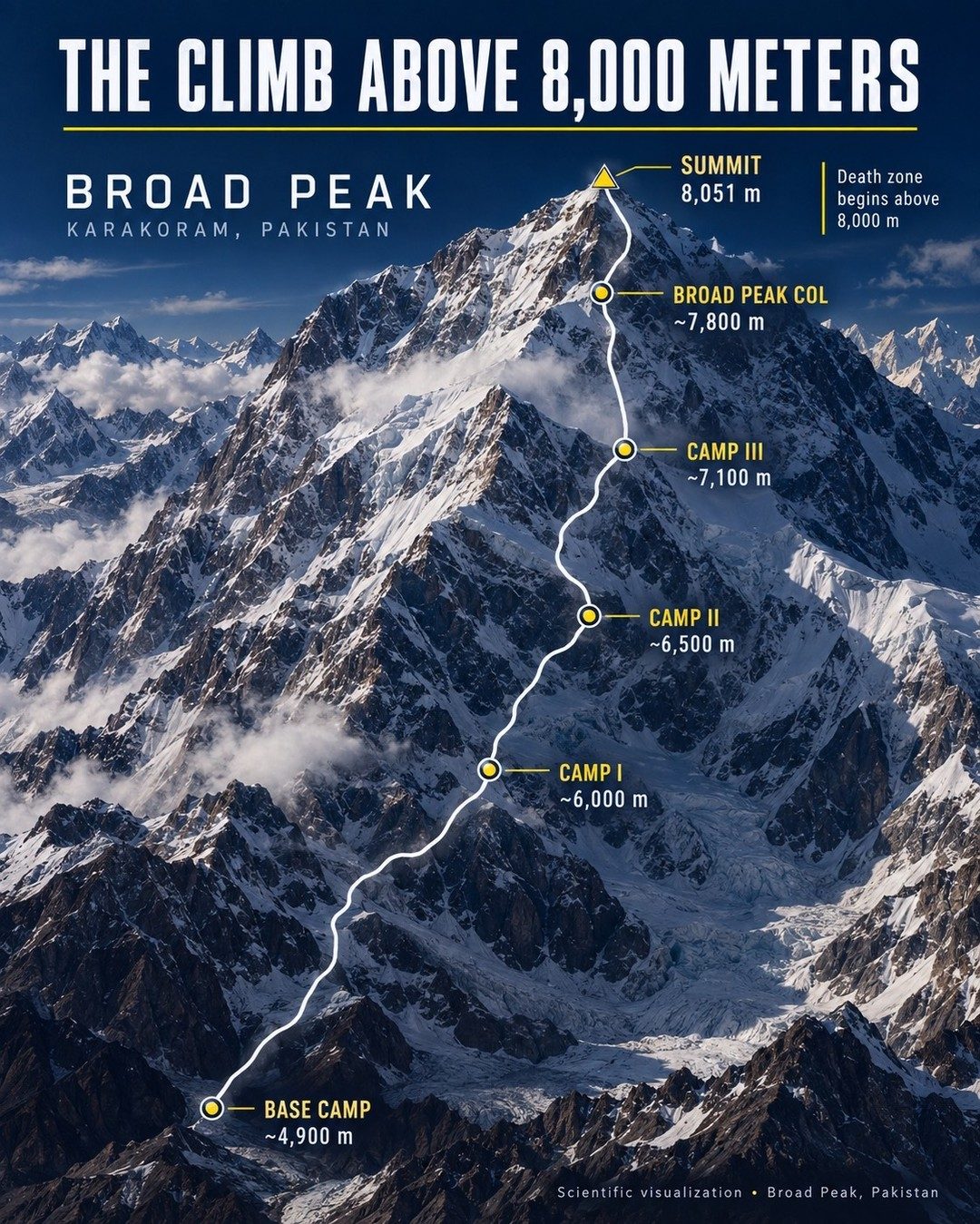
Broad Peak is one of the world's tallest mountains above the 8,000 meters threshold and is part of Pakistan's mighty Karakoram range. This peak is part of what climbers refer to as the "death zone." The terrain is at deadly altitudes where oxygen is scarce and pressure is low, making it difficult to survive. The zone above 8,000 meters of elevation starts at the region known as the death zone. Anything above this altitude can be beyond what the respiration system can achieve. The summit of Broad Peak stands at 8,051 meters. However, the actual journey does not begin at the peak.
The Journey to the Broad Peak Summit
Climbing Broad Peak is a complex journey. The climb incorporates multiple camps along the route, each serving as a strategic pause and resting ground. At the base, the climbers gather at the initial camp, approximately 4,900 meters above sea level. CAMP III, at 7,100 meters, is a midway point on this journey. This is the point where the oxygen starts to take a significant toll on the climbers' bodies. The journey then proceeds to the Broad Peak Col at around 7,800 meters, which is the final stretch before the climbers reach the summit at 8,051 meters.
Beyond the Death Zone
The route to the summit is a perilous journey where challenges lie beyond the isolation. Sticking to the CMAP I stretch includes severe weather, high altitude, and low oxygen levels. Climbers must avoid giving in to exhaustion in this high altitude zone. They must also deal with the broader challenges of the journey and the steep, rocky terrain. Advanced climbing skills, experience, and high-quality equipment are essential for the terrain. There is no room for error in this zero margin zone.
Scientific Visualizations
The graphic provides a broad view of how climbers are encouraged to maintain their climbing. They use vital scientific visualizations to understand the route. It also provides visual data that helps the climbers understand the terrain and the dangers ahead. This route combines scientific visualization with real-time data from various sources to help climbers acclimate and rest at each camp.
Watch the Reel
Related deep dives
Similar reads based on topic and creator.
Recent articles
Fresh deep dives from the latest Reels we unpacked.
Comments
Be the first to comment.