Slow and Steady
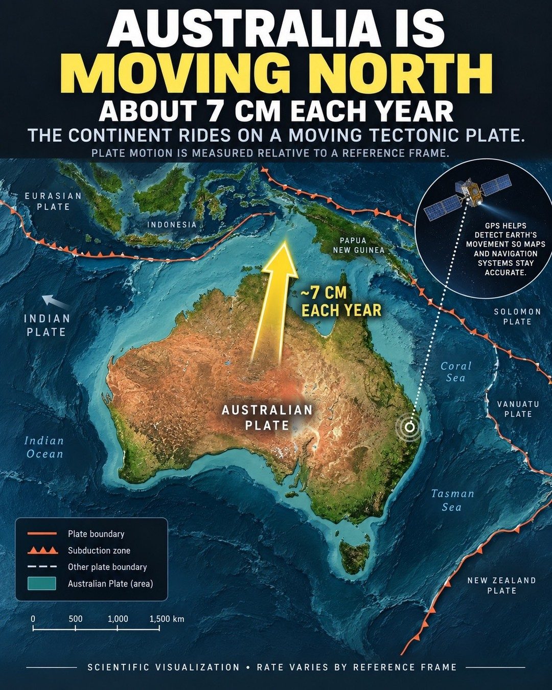
Australia is moving north. It sounds improbable. It sounds dramatic. But it's true. The Australian tectonic plate is shifting a modest 6 to 7 centimeters north-northeast each year. That's slower than a fingernail grows. But in geologic time, such slow and steady incremental shifts have dramatic consequences. This creeping motion is a process that scientists refer to as "continental drift." While it's a slow process, it happens. The continent rides on a moving tectonic plate. Understanding this plate motion is crucial for accurate maps and navigation systems. That’s why GPS technology plays a vital role. By precisely tracking Earth's movement, GPS helps maintain the accuracy of maps and navigation tools. This is not a trivial concern. GPS is a cornerstone of modern geolocation and tracking systems, which in turn support everything from food delivery to construction. The world has come to rely on geolocation and navigation systems.
A Moving Target
The movement of the Australian tectonic plate is relative to a reference frame. This means the speed and direction can appear different depending on the point of reference. For example, from the perspective of the Pacific Plate, Australia might seem to be moving in a different direction or at a different speed. GPS technology helps detect Earth's movement, ensuring that maps and navigation systems stay accurate even as the continents slowly shift across the planet. Without such precise tracking, navigation could quickly become unreliable.
Seeing the Big Picture
Imagine an ever-evolving puzzle. Australia’s northward shift is not an isolated event—it’s part of a global map in constant flux. The visualization shows a map of the region with Australia and its neighboring plates: the Tasman Sea, the Indian Plate, Indonesia, and west to Papua New Guinea, the Coral Sea, and the Solomon Islands. This continental drift isn't just about Australia; it’s about how all the pieces are in motion, affecting everything from landmass configurations to the delicate landscape forming over thousands of years. The map is detailed, showing plate boundaries, subduction zones, and other plate boundaries, illustrating the vastness and complexity of plate tectonics. This scientific visualization illustrates how GPS technology can help detect and track these movements, ensuring that our maps and navigation systems remain accurate as the earth continues to evolve.
Watch the Reel
Related deep dives
Similar reads based on topic and creator.



Recent articles
Fresh deep dives from the latest Reels we unpacked.

Comments
Be the first to comment.