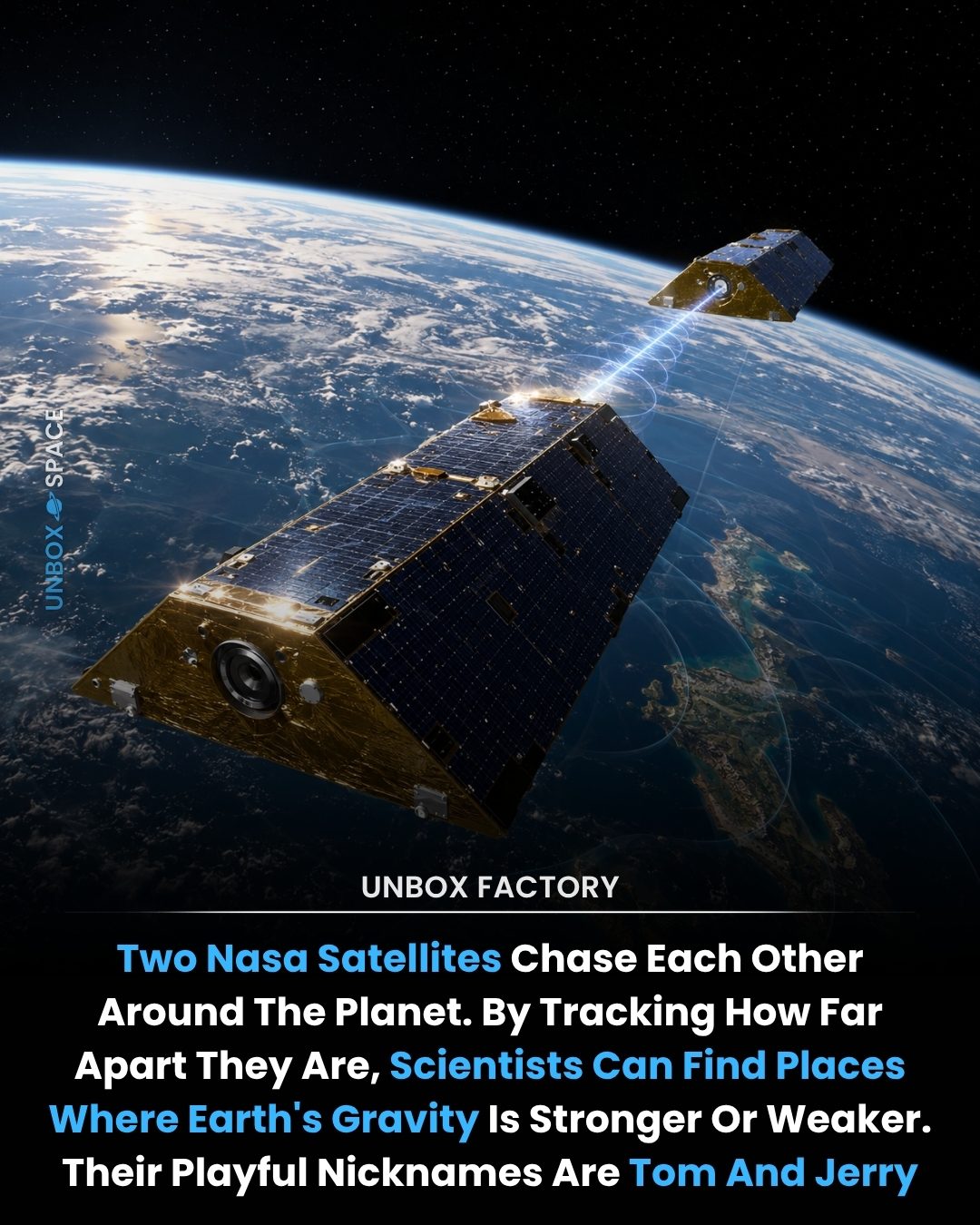
Satellite Tracking: Unveiling Earth's Gravitational Secrets
NASA's twin GRACE-FO (Gravity Recovery and Climate Experiment Follow-On) satellites play a pivotal role in monitoring Earth's gravitational field. Orbiting approximately 490 kilometers (305 miles) above the surface, these satellites maintain a separation of about 220 kilometers (137 miles). By tracking the minute changes in the distance between them, scientists can detect tiny variations in Earth's gravitational field. These variations are crucial for understanding changes in global freshwater supplies, droughts, and climate change.
Why This Matters
The data collected by these satellites is invaluable for several reasons. By measuring changes in the distance between the satellites with an accuracy of just a few microns, scientists can pinpoint areas where groundwater is disappearing, glaciers are melting, ice sheets are shrinking, and sea levels are changing. This information is essential for understanding and predicting the impacts of climate change.
The Science Behind Satellite Tracking
The GRACE-FO Mission
The GRACE-FO mission, a follow-on to the original GRACE mission launched in 2002, continues to be one of the world's most important tools for tracking global freshwater supplies and climate change. The satellites, affectionately nicknamed Tom and Jerry, chase each other around the planet. By tracking how far apart they are, scientists can determine where Earth’s gravity is stronger or weaker.
How It Works
The satellites use a microwave ranging system to measure the distance between them. As they orbit Earth, they encounter regions of varying gravitational pull. These variations cause the leading satellite (Tom) to speed up or slow down relative to the trailing satellite (Jerry). By monitoring these slight changes in distance, scientists can infer the gravitational anomalies and, by extension, the distribution of mass on Earth's surface.
Key Measurements
The primary measurements taken by the GRACE-FO satellites include:
- Changes in Gravity: Variations in Earth's gravitational field indicate changes in mass distribution, which can be linked to phenomena like melting ice sheets and groundwater depletion.
- Groundwater Levels: By detecting changes in gravity, scientists can monitor groundwater levels, which is crucial for managing water resources and understanding drought conditions.
- Glacier and Ice Sheet Dynamics: The satellites track the mass loss from glaciers and ice sheets, providing insights into the rates of ice melting and sea-level rise.
- Sea Level Changes: Variations in gravity can also reveal changes in sea levels, which are essential for understanding the impacts of climate change on coastal regions.
Practical Tips for Understanding Satellite Data
Interpreting Data Visualizations
Data from the GRACE-FO mission is often presented in visualizations that show changes in gravity over time. Understanding these visualizations can help you grasp the broader implications of the data. Look for patterns and trends that indicate areas of significant change, such as regions with rapid ice loss or groundwater depletion.
Accessing Public Data
NASA and the German Aerospace Center (DLR) make GRACE-FO data publicly available. You can access this data through various online portals, which often include tools for visualizing and analyzing the information. Familiarizing yourself with these resources can enhance your understanding of the data and its applications.
Staying Updated
The field of Earth science is constantly evolving, and new insights from the GRACE-FO mission are regularly published. Staying updated with the latest research can provide you with a deeper understanding of how satellite tracking is advancing our knowledge of Earth's climate and environment.
Important Takeaways
The Role of Gravity
Gravity is a fundamental force that affects everything on Earth, from the movement of tectonic plates to the flow of water. By tracking changes in Earth’s gravitational field, we can better understand the dynamics of our planet and the changes it is undergoing.
Global Water Management
The GRACE-FO satellites provide crucial data for managing global water resources. By monitoring groundwater levels and the dynamics of glaciers and ice sheets, scientists can help inform policies and practices aimed at sustainable water management.
Climate Change Insights
The data from these satellites offer valuable insights into the impacts of climate change. By tracking changes in sea levels, melting ice, and groundwater depletion, scientists can better predict future trends and develop strategies for mitigating the effects of a changing climate.
Conclusion
NASA's twin GRACE-FO satellites are revolutionizing our understanding of Earth's gravitational field and its implications for climate change. By tracking the subtle changes in the distance between these satellites, scientists can uncover vital information about groundwater levels, glacier dynamics, and sea-level changes. This data is essential for managing global water resources and predicting the future impacts of climate change. As we continue to monitor Earth from space, the insights gained from the GRACE-FO mission will be invaluable for shaping a sustainable future.
Watch the Reel
Questions readers ask
How do the GRACE-FO satellites, also known as 'Tom & Jerry,' monitor Earth's gravitational changes?
The GRACE-FO satellites, or 'Tom & Jerry,' orbit Earth in tandem. By precisely measuring the distance between the two satellites as they pass over areas with varying gravity, they can detect small changes in Earth’s gravitational field. These fluctuations are indicative of shifts in mass distribution, such as changes in water storage and movements of ice and land features.
What is the significance of measuring the distance between the GRACE-FO satellites?
The minute variations in the distance between the GRACE-FO satellites are crucial for understanding changes in Earth's mass distribution. These changes help scientists track global freshwater shifts, monitor droughts and predict environmental impacts. Additionally, the precision with which the satellites measure these variations enables scientists to observe subtle shifts in the Earth's gravitational field.
How do the GRACE-FO satellites contribute to climate change research?
The GRACE-FO satellites provide crucial data on global freshwater shifts and droughts, which are key indicators of climate change. By tracking changes in Earth's mass distribution, these satellites help scientists understand the impact of climate change on polar ice melt, sea levels, and terrestrial water storage. This information is vital for developing climate models and predicting future environmental impacts.
What makes the GRACE-FO mission unique in NASA's satellite tracking efforts?
The GRACE-FO mission stands out due to its ability to measure minute variations in Earth’s gravitational field. Unlike traditional satellites, GRACE-FO is specifically designed to track gravitational changes by monitoring the distance between two satellites. This unique approach provides detailed insights into global freshwater shifts, droughts, and climate change, making it a valuable tool for understanding Earth's dynamic systems.
How accurate are the measurements taken by the GRACE-FO satellites?
The GRACE-FO satellites can measure changes in the distance between them with an accuracy of just a few microns. This high level of precision allows scientists to detect even the smallest variations in Earth's gravitational field, providing detailed data on changes in global freshwater supplies, land movements, and ice melt. Such accuracy is essential for tracking the subtle shifts in mass distribution that impact environmental processes.
How do the GRACE-FO satellites help in predicting environmental impacts?
By continuously monitoring changes in Earth's gravitational field, the GRACE-FO satellites provide scientists with valuable data on global freshwater shifts and droughts. This information helps in predicting and managing environmental impacts, such as water scarcity, extreme weather events, and changes in land mass. The ability to track these shifts can lead to better preparedness and response strategies for communities affected by environmental changes.
What happens if there are disruptions in the GRACE-FO satellite tracking?
Disruptions in the GRACE-FO satellite tracking can affect the continuous monitoring of Earth's gravitational changes. To mitigate this, the mission relies on a robust system of ground stations and backups, ensuring minimal data loss. However, any interruption can impact the timely delivery of critical information needed for understanding and addressing global freshwater shifts, droughts, and climate change. Regular monitoring and maintenance are essential to maintain the integrity of the data collected by the satellites.
Related deep dives
Similar reads based on topic and creator.
Recent articles
Fresh deep dives from the latest Reels we unpacked.

Comments
Be the first to comment.